2015-05-08 52 1
From Geohashing
Revision as of 19:57, 8 May 2015 by imported>Sourcerer ([live picture] Closest I got. [http://www.openstreetmap.org/?lat=52.48336315&lon=1.66994333&zoom=16&layers=B000FTF @52.4834,1.6699])
| Fri 8 May 2015 in 52,1: 52.4928954, 1.6785815 geohashing.info google osm bing/os kml crox |
Location
In a grazing field on the marshes north east of the Waveney River Centre, Norfolk, UK.
Participants
Expedition
Still to be attempted ...
Photos
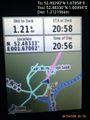
Closest I got. @52.4834,1.6699
