2016-04-02 47 -122
From Geohashing
Revision as of 23:20, 2 April 2016 by imported>Thomcat ([live picture]Grotto waterfall [http://www.openstreetmap.org/?lat=47.56033270&lon=-122.35771130&zoom=16&layers=B000FTF @47.5603,-122.3577])
| Sat 2 Apr 2016 in Seattle: 47.5602894, -122.3576946 geohashing.info google osm bing/os kml crox |
Location
The woods in Pigeon Point, not far off a trail.
Participants
Plans
Happen to be working close by this afternoon, so I checked it out. Very reachable!
- An inaccurate trail map is located here
- I will be at the gate west of the hashpoint just before 4:00. After that, I propose we reach the point itself and then walk through more of Pigeon Point. --Thomcat (talk) 14:32, 2 April 2016 (UTC)
Expedition
Tracklog
Photos
South of here @47.5606,-122.3579
... and down. @47.5605,-122.3577
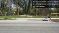
Meeting point for tomorrow's 4:00 expedition @47.5607,-122.3602
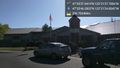
School @47.5629,-122.3569
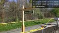
Sign @47.5603,-122.3603

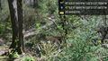
Geohash! @47.5603,-122.3577
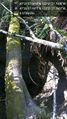
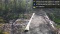
Grotto waterfall @47.5603,-122.3577


Achievements