2017-01-29 52 0
From Geohashing
Revision as of 16:41, 27 January 2017 by imported>Sourcerer (→Plans)
| Sun 29 Jan 2017 in Cambridge, UK: 52.9710690, 0.7476478 geohashing.info google osm bing/os kml crox |
Location
A salt marsh north of Burnham Overy Staithe, Norfolk, UK.
Participants
Plans
Two creek wades will be needed. Low tide is at about 15:20 UTC. In the summer, this would be easy. In January, not so much. I have a track-log of a walk here on 2008-08-26 before I started geohashing.
Expedition
Photos
- Photo Gallery
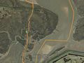
Déjà vu Google Earth Track from 2008

Achievements
Expeditions and Plans
| 2017-01-29 | ||
|---|---|---|
| Buffalo, New York | Pedalpusher, Ashley, Dane, Robin, Simon the dog, Myka the dog | In a field of Amherst State Park, just off a path |
| Innsbruck, Austria | Claralucia9 | In a forest close to Aying south of Munich |
| Pforzheim, Germany | DODO | A lawn near Ölbrunn. |
| Cambridge, United Kingdom | Sourcerer | A salt marsh north of Burnham Overy Staithe, Norfolk, UK. |
Sourcerer's Expedition Links
2017-01-24 52 1 - 2017-01-29 52 0 - 2017-01-31 52 1 - KML file download of Sourcerer's expeditions for use with Google Earth.