2017-04-12 -37 145
From Geohashing
Revision as of 06:20, 12 April 2017 by imported>Thunk ([live picture]A better view of the mountain from the south side of Liverpool Road. [http://www.openstreetmap.org/?lat=-37.84757590&lon=145.31245090&zoom=16&layers=B000FTF @-37.8476,145.3125])
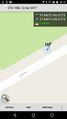
| Wed 12 Apr 2017 in -37,145: -37.8475072, 145.3123621 geohashing.info google osm bing/os kml crox |
Location
Participants
Plans
Expedition
- Hashpoint found and reached. A pretty easy roadside walk. -- Thunk (talk) @-37.8475,145.3124 06:17, 12 April 2017 (GMT+00:00)
Tracklog
Photos
Proof
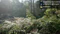
Trees near hash. @-37.8475,145.3124
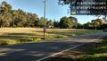
Roadside south @-37.8475,145.3124
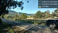
Roadaide north @-37.8475,145.3124
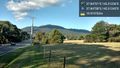
A better view of the mountain from the south side of Liverpool Road. @-37.8476,145.3125


Achievements