2018-06-28 47 -122
| Thu 28 Jun 2018 in Seattle: 47.7725448, -122.1722704 geohashing.info google osm bing/os kml crox |
Location
Just off the Hollyhillis Powerline Trail in West Woodinville - or is it?
Participants
Plans
Solve the mystery on the way to work.
Expedition
Zoomed in on the local coordinates and found it to be right off a trail. Looks good, but powerline trails can go over ponds and scrub bushes. When I switched to the Aerial view, the red flag moved to the west!
The coordinates displayed in the search window also changed, from 47.772544842685306,-122.17227039872789 to 47°46'21.2"N 122°10'20.2"W. It looks like for some reason the west fraction changed from .172270 to .1744591, which is fairly significant.
Bing shows the flag, the aerial view and the bird's eye view at the proper spot. I have had problems with GPS under power wires (and expect to this morning), but is this an instant of Google running into the same thing? Is it related to the nearby street view? Time to solve a mystery!
Tracklog
Photos
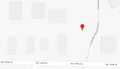
overview map, just off the trail
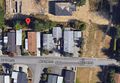
aerial map, further west
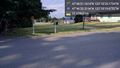
Lots of access to the south @47.7724,-122.1721
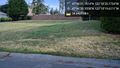
But to the north, a fence! @47.7723,-122.1721
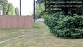
A gap! A bad sign :( @47.7724,-122.1722


Achievements