2019-05-21 52 9
From Geohashing
Revision as of 21:07, 21 May 2019 by imported>Fippe (New Report)
| Tue 21 May 2019 in Hannover: 52.8830994, 9.6959560 geohashing.info google osm bing/os kml crox |
Location
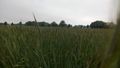
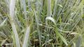
This Geohash is located on a field of rye in Bad Fallingbostel.
Participants
Expedition
Happy Geohashing Day, everyone! From Hannover, I took the train to Bad Fallingbostel, and walked the rest from there.
On the way, I crossed the river Böhme. There was a sign stating that the river used to be the border between France and Germany during Napoleon's times. The Geohash turned out to be on a field of rye. I reached the coordinates, they were close to some tracktor tracks.
After recording proof, I walked back to the train station and took a train home.
Photos
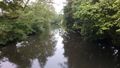
The river Böhme
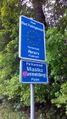
Bad Fallingbostel's sister cities: Périers and Miastko
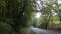
On the way to the Geohash
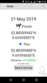
Proof
Surroundings
The Geohash
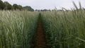
Tractor Tracks


Ribbons
Fippe earned the Land geohash achievement
|
Fippe earned the Consecutive geohash achievement
|
Fippe earned the 2019 Geohashing Day achievement
|