File:Geohash-hedge-end-2009-06-28.png
From Geohashing
Revision as of 17:15, 30 January 2020 by Maintenance script (talk | contribs) (Maintenance script uploaded File:Geohash-hedge-end-2009-06-28.png)
No higher resolution available.
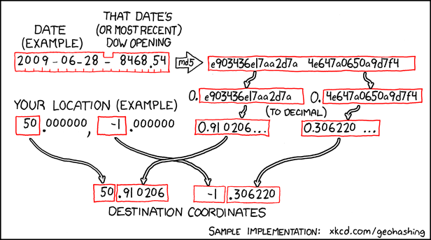
Geohash-hedge-end-2009-06-28.png (616 × 343 pixels, file size: 87 KB, MIME type: image/png)
How the location is calculated to be in Hedge End recreation ground on Sunday 28th June.
File history
Click on a date/time to view the file as it appeared at that time.
| Date/Time | Thumbnail | Dimensions | User | Comment | |
|---|---|---|---|---|---|
| current | 17:15, 30 January 2020 | | 616 × 343 (87 KB) | Maintenance script (talk | contribs) |
- You cannot overwrite this file.
File usage
The following page links to this file: