2008-06-22 47 19
From Geohashing
Revision as of 21:58, 24 June 2008 by imported>Tomtom
| Sun 22 Jun 2008 in Budapest, Hungary: 47.7465293, 19.2642328 geohashing.info google osm bing/os kml crox |
Location
The hashpoint for the graticule was near Vác, between the villages called Váchartyán and Kisnémedi, outside residental areas, on the side of a mound among wheat, maize and rape fields, in a small forest of pines.
Expedition
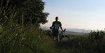
I rode my bike from home to the site. (You can check out my path here, it was a total of 63.9 km / 39.71 mi) The first part of the journey was quite easy, on bike lanes and roads, the close approach made me a bit more sweaty, with up and downhills on dirt roads. I was very much afraid of having a flat tyre because of all the thorns, burrs and thistles, but i went on the right path.
Pictures
- the day of the lone rider
approaching the hashpoint
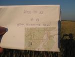
at the site
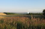
there it is
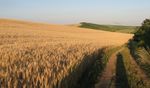
nice blonde fields around


