2021-03-14 -37 144
| Sun 14 Mar 2021 in -37,144: -37.7105588, 144.9821297 geohashing.info google osm bing/os kml crox |
Location
At an abandoned school in Fawkner with a large cycling crew.
Participants
- Felix Dance
- Lachie
- Stevage
- Cam
- Rhonda
- Mdixon4
Expeditions
Felix Dance
I'd seen a few messages pop up at my phone while I was on a brewery crawl of the south-east suburbs the previous day but paid them no mind. However, later in the evening, upon closer inspection, I realised I was being alerted to critical news. Geohash.
It was ideally situated - about an hour's ride up Merri Creek in a tricky-but-achievable location at what looked like a demolished school in Fawkner. I fired off a message to say I was in and then we were on.
To make things a little more special my friend Lachie and I jumped on Lachie's tandem that morning and we rode to the meet-up point. The crew having assembled and encaffeinated at the cafe we headed off up-creek hashwards.
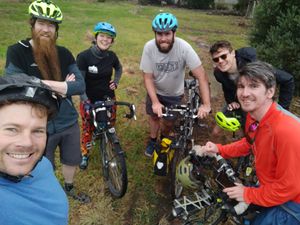
There was Matt, with long beard, who led the charge. Then came Rhonda, of the colourful tights and a strong sense of direction. With them was Cam, who brought the super-power of geohashing indifference and a zest for going along with the crew. Stevage followed, powerful in hash-point noticing and up for any challenge. Lachie and myself took up the rear. A duo inextricably linked by having several steel tubes tieing together our combined transportation. We were away.
The bike path to the hash was winding and friendly, with many passers-by smiling and waving at what they could see was an important mission, a tear in each eye and wistful thought in each head at the task before us. A toilet stop and a broken rear derraileur cable were our only obstacles to arriving at the hash-fence.
A quick scout of the perimeter alerted us to a convenient hole that allowed us passage. We traversed the internal field, past the abandoned and half-demolished school, surrounded by long grass, scattered skips and asphalt carparks broken up by weeds. The windows were smashed and graffiti sprayed across the internal walls. It was like an even more depressing Chernobyl.
Something to cheer us up, however, was reaching the hash. I got my GPS to within 18mm of the hash-point - a new record I believe. And then Stevage broke out the beers. This brought the mood up considerably.
We headed back out (being careful to take a more difficult and circuitous route rather than retracing our path precisely). We took the alternate Upfield bike path to return southwards. Our taste for beer hadn't been sated and a brewery trip was required. The new Upfield Skyrail looming above us only provided further incentive for the adjusted route.
Once our beery lunch was complete we wrangled our way further through the streets of Brunswick to get gelatis before finally separating and heading to our respective homes. Except in my case as I had to ride with Lachie back to his home, having no independant means of transport.
Here is the route we took.
Photos
Achievements
Felix, Matt, Rhonda, Stevage, Lachie and Cam earned the Bicycle geohash achievement
|


