2008-07-19 48 -121
| Fri 18 Jul 2008 in North Cascades: 48.3586744, -121.1485900 geohashing.info google osm bing/os kml crox |
Contents
About
Just off the Mountain Loop Highway, near Granite Falls.
Expeditions
Thomcat
Could be 4pm, could be 5pm - depends on the status of my 2pm appointment in Everett.
Robyn
At 15:40 Robyn and Wade arrived at what satellite views indicated was the head of a trail leading almost directly to the hashpoint. Unfortunately the road was clearly marked with No Tresspassing signs, so we had to stop there, a third of a mile from the hashpoint.
We chalkmarked the pavement and a rock, photographed the GPS, the no trespassing sign, and the tempting trail beyond, and waited hopefully for more geohashers, so we could perhaps adjourn to a more accessible point. We waited until 16:20, whiling away the time playing catch with a large rubber dinosaur purchased for the occasion (Value Village: $2.99). The plan was to hurl it violently at Thomcat, so that he could win the raptor attack achievement. I've since been informed that my dinosaur is not a velociraptor, so it might not count. It DOES go 70 mph when bungied to the back of the motorbike, and, as pictorial evidence below shows, it sort of flies.
Sadly, we did not meet anyone else attempting to access the hash. We noticed a car stop just up the road, for a moment, but they then sped off, without coming to visit.
- Robyn's pictures

Robyn and friend at the gate barring the geohash trail.
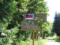
The fateful sign, with evidence of why you shouldn't trespass in the area.

Wade and our flying dinosaur.
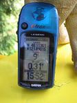
Proof of our proximity to the hashpoint.


