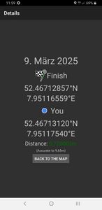
2025-03-09 52 7
| Sun 9 Mar 2025 in 52,7: 52.4671286, 7.9511656 geohashing.info google osm bing/os kml crox |
Location
This Geohash is located at the edge of a forest in in Alfhausen.
Participants
Expedition
In the morning, I took the train to Hesepe and walked the rest of the distance.
On the way, I investigated some circular shapes I noticed on satellite imagery. It was a bit like standing in front of the Pentagon, it really only looks cool in aerial pictures and its shape is not immediately obvious from the ground. The circles turned out to be rings of white birch trees surrounding brown trees. I don't see why they would grow that way naturally (fairy rings exist, but those are mushrooms, not trees), but since that area of the forest was fenced in, I assume the pattern was man-made.
In order to take a shortcut, I needed to cross a creek, but there were no bridges. Fortunately, there was a rock in the middle that I could use to cross it.
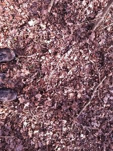
The coordinates were at the edge of a forest along a path. It took a bit of time to zero in to the exact spot, but eventually I managed to do so and recorded proof.
Afterwards, I walked back to the station and took the train back to Osnabrück.
Photos
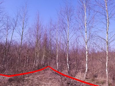
The circles

The site of the Geohash
Proof
The Geohash

Surroundings


Tracklog
Ribbons
Fippe earned the Land geohash achievement
|
Fippe earned the OpenStreetMap achievement
|