2022-12-11 50 16
| Sun 11 Dec 2022 in 50,16: 50.8314379, 16.1527578 geohashing.info google osm bing/os kml crox |
Contents
Location
Near a yellow hiking trail (Nowe Bogaczowice - Trójgarb) close to Jagodnik peak.
Participants
Plans
Planning to start walking 4.5km from 50.8367N, 16.192E at about 9:30. Whole trip between 14 and 17km total.
Expedition
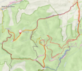
Arrived at start point by car at 9:46. Walked on a red plus yellow trail towards Stare Bogaczowice, then black westbound, then yellow to reach the hash.
Got there at about 10:51. Finding the exact location was a bit difficult because of poor GPS reception (the smartphone hardly fixed on anything, the tracker was significantly better). And, to make things worse, the hash was located on somewhat steep slope between the trail and a stream. I've taped the poster to a nearest tree that was thin enough to reach around it. It blends with the snow for now, but will hopefully stand out (and be reachable easily) when snow is gone.
Got back to starting point at 14:02 after much more walking around.


