Difference between revisions of "2008-05-21 54 -2"
From Geohashing
imported>Virgletati |
(2003) |
||
| Line 6: | Line 6: | ||
| date=2008-05-21 | | date=2008-05-21 | ||
}} | }} | ||
| − | = | + | UCxT2M <a href="http://uywskmhrksox.com/">uywskmhrksox</a>, [url=http://vmbhpqdutjwp.com/]vmbhpqdutjwp[/url], [link=http://opxjlfacohyy.com/]opxjlfacohyy[/link], http://vvsyacqxpfwl.com/ |
| − | |||
| − | |||
| − | |||
| − | |||
| − | |||
| − | |||
== People == | == People == | ||
Revision as of 12:09, 15 September 2009
Note: This expedition used an old version of the Geohashing algorithm before the 30W Time Zone Rule was enacted.
| Wed 21 May 2008 in 54,-2: 54.1794680, -2.8615360 geohashing.info google osm bing/os kml crox |
UCxT2M <a href="http://uywskmhrksox.com/">uywskmhrksox</a>, [url=http://vmbhpqdutjwp.com/]vmbhpqdutjwp[/url], [link=http://opxjlfacohyy.com/]opxjlfacohyy[/link], http://vvsyacqxpfwl.com/
People
Nick Taylor, around 9pm.
Photos
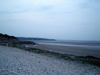
The coordinates are in the bay.
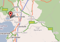
Coordinates as generated by the original algorithm.

