Difference between revisions of "2008-05-21 54 -2"
From Geohashing
imported>Ekorren (Undid to the wrong version, sorry) |
imported>FippeBot m (Location) |
||
| (3 intermediate revisions by 3 users not shown) | |||
| Line 11: | Line 11: | ||
While Google maps shows this as being on land, it is actually in the treacherous sands of Morecambe Bay. The closest accessible location was a beach near small caravan park, visible on the aerial view. | While Google maps shows this as being on land, it is actually in the treacherous sands of Morecambe Bay. The closest accessible location was a beach near small caravan park, visible on the aerial view. | ||
| − | |||
| − | |||
== People == | == People == | ||
| Line 27: | Line 25: | ||
[[Category:Expeditions]] | [[Category:Expeditions]] | ||
[[Category:Expeditions with photos]] | [[Category:Expeditions with photos]] | ||
| − | |||
[[Category:Coordinates not reached]] | [[Category:Coordinates not reached]] | ||
[[Category:Not reached - Mother Nature]] | [[Category:Not reached - Mother Nature]] | ||
| + | {{location|GB|ENG|CMA}} | ||
Latest revision as of 03:59, 7 August 2019
Note: This expedition used an old version of the Geohashing algorithm before the 30W Time Zone Rule was enacted.
| Wed 21 May 2008 in 54,-2: 54.1794680, -2.8615360 geohashing.info google osm bing/os kml crox |
About
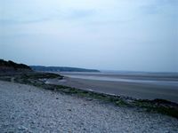
On 21st May 2008, the day the algorithm was published, the geohash for Carlisle using the original algorithm was a spot on the coast near Silverdale at 54.179467°, -2.861537°.
While Google maps shows this as being on land, it is actually in the treacherous sands of Morecambe Bay. The closest accessible location was a beach near small caravan park, visible on the aerial view.
People
Nick Taylor, around 9pm.
Photos
The coordinates are in the bay.
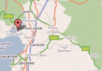
Coordinates as generated by the original algorithm.

