Difference between revisions of "2008-05-23 42 -71"
From Geohashing
imported>Xkcd |
imported>Xkcd |
||
| Line 1: | Line 1: | ||
| − | [[Image:2008-05-23 View.jpg|thumb|300 px|This is where they get desktop backgrounds.]] {{graticule|map=<map lat="42" lon="-71" date="2008-05-23" width=" | + | [[Image:2008-05-23 View.jpg|thumb|300 px|This is where they get desktop backgrounds.]] |
| + | |||
| + | {{graticule|map=<map lat="42" lon="-71" date="2008-05-23" width="268" height="300"/>|maponly=1}} | ||
This geohash is located about 30 meters offshore of a park, in Wassachuset Reservoir. | This geohash is located about 30 meters offshore of a park, in Wassachuset Reservoir. | ||
| Line 5: | Line 7: | ||
== People == | == People == | ||
| − | [[User:Xkcd|Randall]], davean, and Tesia got within about | + | [[User:Xkcd|Randall]], davean, and Tesia got within about 35 meters of this hash around 5:15 PM. We couldn't find any signs of boats anywhere near the dike (it's a reservoir, so perhaps they're touchier about who does what in it). It was much too deep to wade, and we weren't hardcore enough to jump in. Next time! |
| − | <gallery caption="Pictures" widths="200px" heights=" | + | <gallery caption="Pictures" widths="200px" heights="150px" perrow="2"> |
Image:Reservoir entrance.jpg|The entrance to the park/dike. | Image:Reservoir entrance.jpg|The entrance to the park/dike. | ||
Image:2008-05-23-Location.jpg|Proof of location, if you accept my shell script. | Image:2008-05-23-Location.jpg|Proof of location, if you accept my shell script. | ||
| + | Image:2008-05-23 not quite.jpg|Proof that I couldn't QUITE get there without getting wet. | ||
Image:2008-05-23 42.jpg|And look what license plate we spotted on the way. | Image:2008-05-23 42.jpg|And look what license plate we spotted on the way. | ||
</gallery> | </gallery> | ||
Revision as of 00:19, 24 May 2008

| <map lat="42" lon="-71" date="2008-05-23" width="268" height="300"/> |
[[Category:Meetup in {{{lat}}} {{{lon}}}| ]]
This geohash is located about 30 meters offshore of a park, in Wassachuset Reservoir.
People
Randall, davean, and Tesia got within about 35 meters of this hash around 5:15 PM. We couldn't find any signs of boats anywhere near the dike (it's a reservoir, so perhaps they're touchier about who does what in it). It was much too deep to wade, and we weren't hardcore enough to jump in. Next time!
- Pictures
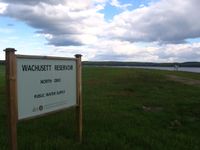
The entrance to the park/dike.
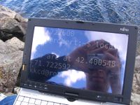
Proof of location, if you accept my shell script.
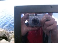
Proof that I couldn't QUITE get there without getting wet.

And look what license plate we spotted on the way.


