Difference between revisions of "2008-05-28 39 -105"
imported>Mgashwood |
m |
||
| (17 intermediate revisions by 6 users not shown) | |||
| Line 5: | Line 5: | ||
| date=2008-05-28 | | date=2008-05-28 | ||
}} | }} | ||
| + | |||
[[Image:20080528-The_Proof.jpg|thumb|250 px|May 28 - I'm Here!]] | [[Image:20080528-The_Proof.jpg|thumb|250 px|May 28 - I'm Here!]] | ||
| − | 39. | + | 39.687451°, -105.212208° |
| + | = Summary = | ||
| + | The [[Denver West, Colorado|Denver West]] location today ({{egl|2008-05-28|39|-106|text=39.687451°,-105.212208°}}) was reached by one person: Me (Mike). The coordinates were in the Matthews-Winters Open Space Park, approximately 1 mile from the parking lot. | ||
| + | I left Golden around 5:30, arrived at the parking lot at 5:40, and walked up the Red Rocks Trail. Using only a topographic map, I found the approximate spot (within a 7 meter circle, more accurate than a GPS). After a few pictures, I went exploring. Up the hill (West) from the location was a little grave yard, and further up was a No Trespassing Sign. I passed many bikers on the trail (as well as the Park Ranger). After that, I headed back to the crowded parking lot. Got into my car and drove home again. | ||
| − | = | + | == Trivia == |
| − | The | + | That graveyard contains one of the oldest known graves in Colorado, belonging to the Rev. I.R. Dean, who died at age 31 on Aug. 12th 1860. The marker reads "I am at rest." There was once a town, called Mt. Vernon, located nearby. (This is secondhand information from a page that [http://64.233.167.104/search?q=cache:STL5Q4L1O9YJ:ftp.rootsweb.com/pub/usgenweb/co/jefferson/cemeteries/mvernon.txt no longer exists]. I've wanted to check that spot for years. Guess I should start Geohashing! -Karmen) |
| − | + | <gallery widths="200px" perrow=1> | |
| + | Image:20080528-Grave.jpg|<center>You mean...this grave?</center> | ||
| + | </gallery> | ||
| + | : -Mike | ||
| − | ==Geohashers== | + | == Geohashers == |
Total: 1 | Total: 1 | ||
| − | *Mike | + | *[[User:Mgashwood|Mike]] |
| − | ==Pictures== | + | == Pictures == |
<gallery widths="190px" perrow=3> | <gallery widths="190px" perrow=3> | ||
Image:20080528-Topo_Map.jpg|<center>My Map</center> | Image:20080528-Topo_Map.jpg|<center>My Map</center> | ||
Image:20080528-Begining_of_Trail.JPG|<center>Begining of Red Rocks Trail</center> | Image:20080528-Begining_of_Trail.JPG|<center>Begining of Red Rocks Trail</center> | ||
| − | Image:20080528-Parking_Lot.jpg|<center>The Parking Lot | + | Image:20080528-Parking_Lot.jpg|<center>The Parking Lot from the Top of the Hill</center> |
Image:20080528-Graveyards.jpg|<center>Small Graveyard in Front<br>Larger Graveyard in Back</center> | Image:20080528-Graveyards.jpg|<center>Small Graveyard in Front<br>Larger Graveyard in Back</center> | ||
Image:20080528-Funny_Sign.jpg|<center>A Sign!</center> | Image:20080528-Funny_Sign.jpg|<center>A Sign!</center> | ||
| Line 31: | Line 38: | ||
Image:20080528-Crowded_Lot.jpg|<center>The Lot was Full!</center> | Image:20080528-Crowded_Lot.jpg|<center>The Lot was Full!</center> | ||
</gallery> | </gallery> | ||
| + | |||
[[Category:Expeditions]] | [[Category:Expeditions]] | ||
[[Category:Expeditions with photos]] | [[Category:Expeditions with photos]] | ||
| + | [[Category:Coordinates reached]] | ||
| + | {{location|US|CO|JE}} | ||
Latest revision as of 22:20, 18 March 2022
| Wed 28 May 2008 in 39,-105: 39.6874509, -105.2122076 geohashing.info google osm bing/os kml crox |

39.687451°, -105.212208°
Contents
Summary
The Denver West location today (39.687451°,-105.212208°) was reached by one person: Me (Mike). The coordinates were in the Matthews-Winters Open Space Park, approximately 1 mile from the parking lot.
I left Golden around 5:30, arrived at the parking lot at 5:40, and walked up the Red Rocks Trail. Using only a topographic map, I found the approximate spot (within a 7 meter circle, more accurate than a GPS). After a few pictures, I went exploring. Up the hill (West) from the location was a little grave yard, and further up was a No Trespassing Sign. I passed many bikers on the trail (as well as the Park Ranger). After that, I headed back to the crowded parking lot. Got into my car and drove home again.
Trivia
That graveyard contains one of the oldest known graves in Colorado, belonging to the Rev. I.R. Dean, who died at age 31 on Aug. 12th 1860. The marker reads "I am at rest." There was once a town, called Mt. Vernon, located nearby. (This is secondhand information from a page that no longer exists. I've wanted to check that spot for years. Guess I should start Geohashing! -Karmen)
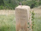
You mean...this grave?

- -Mike
Geohashers
Total: 1
Pictures
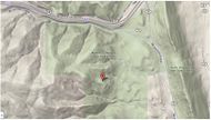
My Map 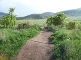
Begining of Red Rocks Trail 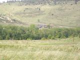
The Parking Lot from the Top of the Hill 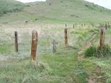
Small Graveyard in Front
Larger Graveyard in Back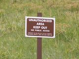
A Sign! 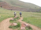
Warning, Bikers on Trail 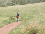
Bigger Warning, Park Ranger on Trail 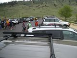
The Lot was Full!


