Difference between revisions of "2008-05-31 34 -118"
imported>SouthLAMike |
imported>FippeBot m (Location) |
||
| (26 intermediate revisions by 9 users not shown) | |||
| Line 3: | Line 3: | ||
| lat=34 | | lat=34 | ||
| lon=-118 | | lon=-118 | ||
| − | | date=2008-05- | + | | date=2008-05-31 |
| graticule_name=Los Angeles | | graticule_name=Los Angeles | ||
| graticule_link=Los Angeles, California | | graticule_link=Los Angeles, California | ||
}} | }} | ||
| + | |||
| + | == Meetup == | ||
| + | |||
| + | The actual point was in a self-storage place under the 10 Fwy, or alternately was on the 10 Freeway. At least four people showed up. | ||
| + | |||
| + | Architecturally, that neighborhood is interesting, because it has some pre-world-war-one housing, which is uncommon in LA. | ||
| + | |||
| + | (If no one has pictures, I'll return later and take some for the record. -- [[user:SouthLAMike|Mike]]) | ||
| + | |||
| + | :Ahem. Those showing up at 4pm sharp may want to hang around for a bit to meet those of us underestimating trafic and getting there, say, 25 min late. I took a few pics; will post when I get home. --[[User:IlyaHaykinson|IlyaHaykinson]] 00:22, 1 June 2008 (UTC) | ||
| + | |||
| + | Was a bit of a bust. I think it had something to do with the location. I'm Adam, the white guy in the red overshirt, and whoever that was in the SUV: if you'd waited another 5-10 minutes, you would have met at least Mike! Ah well. -- Adam | ||
| + | |||
| + | I did a drive-over of the map coordinates at an altitude of about 50 feet (i.e. on the 10 Fwy) at 3:59PM. (Can we get a rules committee adjudication as to whether this constitutes successfully reaching the spot?) Afterwards, I circled back and entered the parking lot of the storage facility and I said hello to Adam as I exited (I'm the SUVer). I looked for someplace to park in the area but gave up on that. So, call this the first "drive-by meetup," or maybe "meetup, L.A. style." --[[user:Bill|Bill]] | ||
| + | |||
| + | <gallery perrow="3"> | ||
| + | Image:2008-05-31 34 -118 closest street corner.jpg|The closest street corner | ||
| + | Image:2008-05-31 34 -118 not coordinates.jpg|The numbers here are ''not'' the coordinates | ||
| + | Image:2008-05-31 34 -118 storage units 1.jpg|This is roughly where the coordinates are | ||
| + | Image:2008-05-31 34 -118 storage units sign.jpg|They even provided directions to the coordinates | ||
| + | Image:2008-05-31 34 -118 under the freeway.jpg|A view from just outside the geohash location | ||
| + | </gallery> | ||
== Planning Information == | == Planning Information == | ||
| Line 15: | Line 37: | ||
* [[user:SouthLAMike|Mike]] suggests that meeting on the 10 fwy might be a bad idea. | * [[user:SouthLAMike|Mike]] suggests that meeting on the 10 fwy might be a bad idea. | ||
| + | |||
| + | * [[user:Daniel.v.h|Daniel]] notes that it seems there might be an area beneath the freeway that is safely accessible (although he regrets he will not be able to make it because of a prior commitment). However, upon closer inspection (Google Maps Street View), he realizes that it is a fenced-in area, apparently a self-storage facility[http://www.ladowntownmini.com/]. It seems the only solution is for someone to figure out which storage unit is located at the exact coordinates, rent it out, and hold a party inside it. | ||
| + | |||
| + | * We might be able to convince the owner to humor us by letting us walk around the facility, if we can convince him that Geohashing is legit and non-destructive [[Special:Contributions/66.215.20.28|66.215.20.28]] 03:10, 31 May 2008 (UTC) Looking at it, there seems to be a specific unit under the marker, as opposed to there being a road there, but I'm not sure. Hopefully we can at least get whoever is running the facility to humor us with a tour! Hopefully at least one of you can speak spanish, as it's a definite possibility that whoever is running it is less than fluent in english. [[Special:Contributions/66.215.20.28|66.215.20.28]] 03:20, 31 May 2008 (UTC) | ||
| + | |||
| + | * '''(edit)''' FWIW, Rigo's Tacos (22nd and Union) and Ragazzi Coffee (23rd and Union) are by there. -- Mike | ||
| + | |||
| + | * SouthLAMike, thanks for scoping out the place but I think you’re missing the point. I feel that Geohashing is about trying to understand the world by exploring a true random sample of it. I already know what a taco place and a coffee house are like. I want to see what the area under the freeway is like today. | ||
| + | |||
| + | ::* Fair 'nuff. -- Mike | ||
| + | |||
| + | [[Category:Expeditions]] | ||
| + | [[Category:Expeditions with photos]] | ||
| + | [[Category:Coordinates reached]] | ||
| + | <!-- Rules committee (of one) indicates success --> | ||
| + | {{location|US|CA|LO}} | ||
Latest revision as of 04:27, 7 August 2019
| Sat 31 May 2008 in Los Angeles: 34.0374871, -118.2812665 geohashing.info google osm bing/os kml crox |
Meetup
The actual point was in a self-storage place under the 10 Fwy, or alternately was on the 10 Freeway. At least four people showed up.
Architecturally, that neighborhood is interesting, because it has some pre-world-war-one housing, which is uncommon in LA.
(If no one has pictures, I'll return later and take some for the record. -- Mike)
- Ahem. Those showing up at 4pm sharp may want to hang around for a bit to meet those of us underestimating trafic and getting there, say, 25 min late. I took a few pics; will post when I get home. --IlyaHaykinson 00:22, 1 June 2008 (UTC)
Was a bit of a bust. I think it had something to do with the location. I'm Adam, the white guy in the red overshirt, and whoever that was in the SUV: if you'd waited another 5-10 minutes, you would have met at least Mike! Ah well. -- Adam
I did a drive-over of the map coordinates at an altitude of about 50 feet (i.e. on the 10 Fwy) at 3:59PM. (Can we get a rules committee adjudication as to whether this constitutes successfully reaching the spot?) Afterwards, I circled back and entered the parking lot of the storage facility and I said hello to Adam as I exited (I'm the SUVer). I looked for someplace to park in the area but gave up on that. So, call this the first "drive-by meetup," or maybe "meetup, L.A. style." --Bill
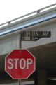
The closest street corner
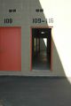
The numbers here are not the coordinates
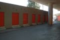
This is roughly where the coordinates are
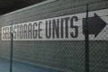
They even provided directions to the coordinates
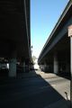
A view from just outside the geohash location


Planning Information
- As of 16:04, 30 May 2008 (UTC), the map lookup is incorrect. Use the main page coords. See Template talk:Expeditions/2008-05-31. --Tim P 16:04, 30 May 2008 (UTC)
- If you go by the coords on the main page you get a location right on the 10 freeway, near the intersection of Union and 20th, by USC. [[1]]
- Mike suggests that meeting on the 10 fwy might be a bad idea.
- Daniel notes that it seems there might be an area beneath the freeway that is safely accessible (although he regrets he will not be able to make it because of a prior commitment). However, upon closer inspection (Google Maps Street View), he realizes that it is a fenced-in area, apparently a self-storage facility[2]. It seems the only solution is for someone to figure out which storage unit is located at the exact coordinates, rent it out, and hold a party inside it.
- We might be able to convince the owner to humor us by letting us walk around the facility, if we can convince him that Geohashing is legit and non-destructive 66.215.20.28 03:10, 31 May 2008 (UTC) Looking at it, there seems to be a specific unit under the marker, as opposed to there being a road there, but I'm not sure. Hopefully we can at least get whoever is running the facility to humor us with a tour! Hopefully at least one of you can speak spanish, as it's a definite possibility that whoever is running it is less than fluent in english. 66.215.20.28 03:20, 31 May 2008 (UTC)
- (edit) FWIW, Rigo's Tacos (22nd and Union) and Ragazzi Coffee (23rd and Union) are by there. -- Mike
- SouthLAMike, thanks for scoping out the place but I think you’re missing the point. I feel that Geohashing is about trying to understand the world by exploring a true random sample of it. I already know what a taco place and a coffee house are like. I want to see what the area under the freeway is like today.
- Fair 'nuff. -- Mike