Difference between revisions of "2008-06-01 37 -121"
imported>Foobert (→Execution/aftermath) |
imported>FunkyTuba |
||
| Line 40: | Line 40: | ||
Image:2008-06-01 37 -121-Tapin-1.JPG|[[User:Tapin|Joe]] made it at 10am | Image:2008-06-01 37 -121-Tapin-1.JPG|[[User:Tapin|Joe]] made it at 10am | ||
Image:2008-06-01 37 -121-Tapin-2.JPG|...and here's the GPS proof | Image:2008-06-01 37 -121-Tapin-2.JPG|...and here's the GPS proof | ||
| + | Image:BaseCamp.jpg|A dirt field in the vicinity served as base of operations for the 4pm group. | ||
| + | Image:2008-06-01_37_-121-The_Island_From_Afar.JPG|The view of the site from an area outside of the "no pedestrian" zone, while geohashers braver than I mark out the exact spot. | ||
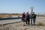
Image:2008-06-01 37 -121-ClaireandPete.JPG|Claire and Pete got pretty close, but weren't allowed to risk life and limb to get to the exact point. | Image:2008-06-01 37 -121-ClaireandPete.JPG|Claire and Pete got pretty close, but weren't allowed to risk life and limb to get to the exact point. | ||
| + | Image:Admonished.jpg|Nanny state warnings... | ||
| + | Image:Violated.jpg|...could not deter us. | ||
| + | Image:2008-06-01_37_-121-Bicycles.JPG|Bicyclists showed up in full force (for values of force == 2). | ||
| + | Image:2008-06-01-a.JPG|Gang of 4 that made it at 4pm[-ish]. Someone's got a GPS-shot... | ||
| + | Image:TheProof.jpg|The proof on Zigdon's GPS. | ||
| + | Image:IMG_4579.JPG|Another of the four intrepid geohashers on the spot. | ||
| + | Image:Theview.jpg|The view from the geohash itself back along the access route. | ||
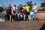
| + | Image:Crowd.jpg|The cheering crowd. | ||
| + | Image:Geotrashing.jpg|Paying our debt to society. | ||
| + | Image:Retreat.jpg|Dodging traffic: land and air. | ||
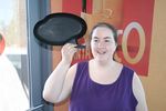
Image:2008-06-01 37 -121-Quiznohashing.JPG|Quiznohashing | Image:2008-06-01 37 -121-Quiznohashing.JPG|Quiznohashing | ||
| − | Image: | + | Image:Relsquicaption.jpg|... |
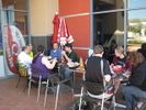
| − | Image: | + | Image:TheWholeCrew.jpg|All of us at the closest eating place to the geohash... a Quizno's. |
| − | + | ||
</gallery> | </gallery> | ||
[[Category:Expeditions]] | [[Category:Expeditions]] | ||
[[Category:Expeditions with photos]] | [[Category:Expeditions with photos]] | ||
Revision as of 21:28, 2 June 2008
| Sun 1 Jun 2008 in 37,-121: 37.3491079, -121.9162389 geohashing.info google osm bing/os kml crox |
Planning details
Note: This was originally posted in the SF graticule
Logistics
- Google Maps link
- Nice, convenient location that just happens to be completely impractical: Highway 880 exit to Coleman Ave, in the dirt next to the off-ramp.
- Easy access by foot, suggest parking on nearby Spring Street.
- The entire length of Spring Street is marked "No Stopping Any Time". I suggest parking in the dirt lot at Hedding and Walnut (about 100 feet down Hedding from the intersection of Hedding and Coleman) --Tapin 18:04, 1 June 2008 (UTC)
- Umm, I'm confused by these instructions. It doesn't look like Walnut intersects with Hedding at all, and it seems a bit out of the way. Maybe someone could provide a link to the spot you mean? --Mystitat
- Sorry, yes, Google Maps doesn't seem to list the road, but it's definitely there and marked. Walnut continues to the southeast of the very center of this picture; the dirt lot I referenced is to the northwest of Hedding at that spot. You can see the points where the road is supposed to go in that map, but it's an old picture. --Tapin 19:27, 1 June 2008 (UTC)
- Umm, I'm confused by these instructions. It doesn't look like Walnut intersects with Hedding at all, and it seems a bit out of the way. Maybe someone could provide a link to the spot you mean? --Mystitat
- The entire length of Spring Street is marked "No Stopping Any Time". I suggest parking in the dirt lot at Hedding and Walnut (about 100 feet down Hedding from the intersection of Hedding and Coleman) --Tapin 18:04, 1 June 2008 (UTC)
- Easy access by foot, suggest parking on nearby Spring Street.
- Now taking suggestions for local establishments at which to meet -- Google Earth suggests there's a Quizno's just past Hedding on the southwest side of Coleman?
- I suggest that we meet at the actual spot as best we can (NOTE: do not cross the freeway illegally!) at 4:00pm, get a few pictures, discuss actual "sit down meet-up" locations and leave by 4:15. In addition, I will bring the makings of a small, make-shift marker for this most infamous of meetups, hopefully to be buried under layers of concrete and discovered eons hence by future archeologists... :)
- The actual spot is mildly difficult, not to mention marked "No pedestrians" (which I, uh, noticed on the way back). However, there's a huge empty dirt field directly east of the spot that's extremely easily accessible. --Tapin 18:04, 1 June 2008 (UTC)
Intended attendees
- I'll certainly be there. Zigdon 20:02, 30 May 2008 (UTC)
- I'll be there, possibly with one or two others. Closest places I can think of are a cheap sandwich shop and a Mexican restaurant at the corner of Elm and Emory, just a few blocks away, but I've never eaten there. There are also several good restaurants (Pasta Pomodoro, Roxie's New York Pizza, Tee Nee Thai), all located a short distance away on the Alameda at Race Street. Archchancellor 21:25, 31 May 2008 (UTC)
- I'll try my darndest to be there. Mystitat
- I'll be there... not sure how many kids I'll bring. Mmmmm. Pizza. FunkyTuba 06:54, 1 June 2008 (UTC)
- Ted and Vicki will try to be there.
- I'll try to be there --Tapin 19:47, 1 June 2008 (UTC)
Execution/aftermath
- Joe scouted the spot at about 10am
- foobert: I had prior commitments at the designated time. But, on my way there, I drove the northbound on-ramp at 2:50PM. There were 2 hashers sitting against the barrier under the sign. I honked repeatedly, they jumped up and waived energetically. Even at 30 mph, I felt the bond. Blue Jetta wagon ring a bell for anyone?
- Ted Made it to the spot @4pm[-ish] with others. Vicki hung out on the other side of the "Absolutely no pedestrians, for any reason, ever; this means you" sign.

Joe made it at 10am
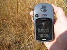
...and here's the GPS proof
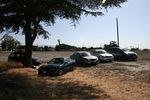
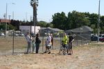
A dirt field in the vicinity served as base of operations for the 4pm group.
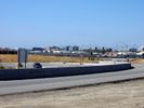
The view of the site from an area outside of the "no pedestrian" zone, while geohashers braver than I mark out the exact spot.
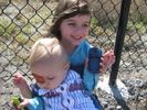
Claire and Pete got pretty close, but weren't allowed to risk life and limb to get to the exact point.
Nanny state warnings...

...could not deter us.
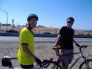
Bicyclists showed up in full force (for values of force == 2).
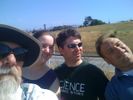
Gang of 4 that made it at 4pm[-ish]. Someone's got a GPS-shot...
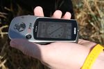
The proof on Zigdon's GPS.
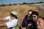
Another of the four intrepid geohashers on the spot.
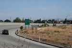
The view from the geohash itself back along the access route.
The cheering crowd.
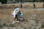
Paying our debt to society.
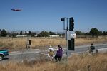
Dodging traffic: land and air.
Quiznohashing
...
All of us at the closest eating place to the geohash... a Quizno's.


