Difference between revisions of "2008-06-01 60 24"
imported>Peldie |
m |
||
| (8 intermediate revisions by 3 users not shown) | |||
| Line 16: | Line 16: | ||
*Wildmage | *Wildmage | ||
This was the first geohash experience for all of us, yay geekness \o/ | This was the first geohash experience for all of us, yay geekness \o/ | ||
| − | + | ||
| + | ==Achievements== | ||
| + | *Land Geohash | ||
| + | *<s>North Geohash</s> ([[2008-06-01 62 5]] was reached a few hours earlier) | ||
| + | |||
| + | I think it doesn't qualify as MNIMB, altough some climbing and descending was involved. | ||
==Photos== | ==Photos== | ||
<gallery> | <gallery> | ||
| − | Image:Oscarin_kamera_-08_4_022.jpg|Sign at the gates of the recycling plant | + | Image:Oscarin_kamera_-08_4_022.jpg|Sign at the gates of the recycling plant - no trespassing and video surveillance signs also visible. |
| − | Image:Oscarin_kamera_-08_4_023.jpg|Wildmage pointing to the direction of destination | + | Image:Oscarin_kamera_-08_4_023.jpg|Wildmage pointing to the direction of destination. |
| + | Image:Oscarin_kamera_-08_4_035.jpg|Reached this destination. Not a GPS screen, but it's something! | ||
| + | Image:Oscarin_kamera_-08_4_032.jpg|We were a bit intimidated to park our car just in front of this yard... | ||
| + | Image:Oscarin_kamera_-08_4_039.jpg|X marks the spot - almost. Motocrossers seem to get something out of these signs. | ||
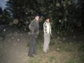
| + | Image:Oscarin_kamera_-08_4_033.jpg|delsku and Peldie standing at the spot, holding the proof paper. | ||
| + | Image:Oscarin_kamera_-08_4_043.jpg|delsku inspecting a possible velociraptor entry point. Beware, metal workers! | ||
| + | Image:Oscarin_kamera_-08_4_054.jpg|Peldie, Wildmage (and hat) and the faithful Geohash-mobile. It's Korean. | ||
</gallery> | </gallery> | ||
| + | |||
| + | [[Category:Expeditions]] | ||
| + | [[Category:Expeditions with photos]] | ||
| + | [[Category:Coordinates reached]] | ||
| + | [[Category:Expedition without GPS]] | ||
| + | {{location|FI|18}} | ||
Latest revision as of 18:56, 2 February 2023
| Sun 1 Jun 2008 in 60,24: 60.3491079, 24.9162389 geohashing.info google osm bing/os kml crox |
The Destination
We had a spontaneous idea of going for a geohash trip altough the time was already 10pm. We (Peldie and delsku) picked up Wildmage to come with us and headed for the destination. An aerial photo, compared to some terrain maps of the destination showed us that the place we were looking for was actually situated behind the largest airport of Finland (the Helsinki-Vantaa airport) in the city of Vantaa. It was a corner of a fence of some sort that belonged to a scrap metal processing plant. Luckily for us, the place was easily reachable by car and the spot was situated on the public side of the fence. Altough we didn't have any kind of electronical GPS or other positioning system, we were able to locate ourselves accurately with the help of aerial photos and maps. Reaching the point was fairly easy, even though it was in the middle of a forest, on a top of a hill, as there was a motocross training paths in the area that helped our journey through the woods.
The Group
- Peldie
- delsku
- Wildmage
This was the first geohash experience for all of us, yay geekness \o/
Achievements
- Land Geohash
North Geohash(2008-06-01 62 5 was reached a few hours earlier)
I think it doesn't qualify as MNIMB, altough some climbing and descending was involved.
Photos
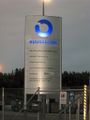
Sign at the gates of the recycling plant - no trespassing and video surveillance signs also visible.
Wildmage pointing to the direction of destination.
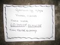
Reached this destination. Not a GPS screen, but it's something!
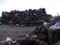
We were a bit intimidated to park our car just in front of this yard...
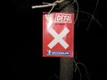
X marks the spot - almost. Motocrossers seem to get something out of these signs.
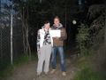
delsku and Peldie standing at the spot, holding the proof paper.
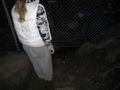
delsku inspecting a possible velociraptor entry point. Beware, metal workers!
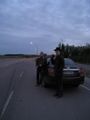
Peldie, Wildmage (and hat) and the faithful Geohash-mobile. It's Korean.


