Difference between revisions of "2008-06-01 62 5"
imported>AshleyMorton |
imported>FippeBot m (Location) |
||
| (4 intermediate revisions by 2 users not shown) | |||
| Line 6: | Line 6: | ||
}} | }} | ||
| − | A nice quick walk from Ulsteinvik. The location was in a section of moorland just north of the main road from Ulsteinvik to Hareid. [[User:AshleyMorton|AshleyMorton]] got there earlier than he'd expected (about 15:00), so ended up sitting on a rock for an hour, reading the Economist. Dedicated to the principles of geohashing, but not really expecting to find anyone else at the site, he brought a deck of cards, and played solitaire. Lost both times. Damn. | + | A nice quick walk from Ulsteinvik. The location was in a section of moorland just north of the main road from Ulsteinvik to Hareid. [[User:AshleyMorton|AshleyMorton]] got there earlier than he'd expected (about 15:00), so ended up sitting on a rock for an hour, reading the Economist. Dedicated to the principles of geohashing, but not really expecting to find anyone else at the site, he brought a deck of cards, and played solitaire. Lost both times. Damn. |
| + | |||
| + | <gallery widths="150px" heights="100px" perrow="3"> | ||
| + | Image:2006-06-01_62_5_b.jpg|The morning dawned humid and overcast. | ||
| + | Image:2006-06-01_62_5_c.jpg|Supplies were purchased. | ||
| + | Image:2006-06-01_62_5_d.jpg|Nice little creek that the initial path passed by. | ||
| + | Image:2006-06-01_62_5_e.jpg|Up the hill... | ||
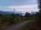
| + | Image:2006-06-01_62_5_f.jpg|Then the path looked like it was getting a little more rustic. | ||
| + | Image:2006-06-01_62_5_r.jpg|Until I realised that there was a light fixture on the side of the path - turns out this path is a lit trail for wintertime cross-country skiing. Huh. | ||
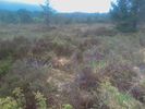
| + | Image:2006-06-01_62_5_g.jpg|Now we're off trail for the last 400m or so. The little creek doesn't look like much, until I realise that there's one every 6 feet. This place was not so great the day after a rainfall! | ||
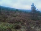
| + | Image:2006-06-01_62_5_h.jpg|Okay, made it! This looks Northwest. | ||
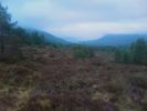
| + | Image:2006-06-01_62_5_i.jpg|North. | ||
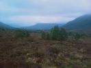
| + | Image:2006-06-01_62_5_j.jpg|Northeast. | ||
| + | Image:2006-06-01_62_5_k.jpg|East. | ||
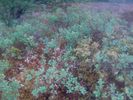
| + | Image:2006-06-01_62_5_l.jpg|Down. | ||
| + | Image:2006-06-01_62_5_m.jpg|Oops, lost the plot there - Uh... South-ish. | ||
| + | Image:2006-06-01_62_5_n.jpg|Played Solitaire - lost. | ||
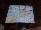
| + | Image:2006-06-01_62_5_o.jpg|Same thing. That's the map of my island. | ||
| + | Image:2006-06-01_62_5_p.jpg|You can tell how close I am to the road. What you can't tell is how wet my feet are. | ||
| + | Image:Image-2006-06-01 62 5 a.jpg|I'm pretty sure this qualifies as "stupidly grinning" - That's me. ([[User:AshleyMorton|AshleyMorton]]) | ||
| + | Image:2006-06-01_62_5_q.jpg|So does this, but this time I'm wearing a Norwegian sweater. | ||
| + | |||
| + | </gallery> | ||
| + | |||
| + | [[Category:Expeditions]] | ||
| + | [[Category:Expeditions with photos]] | ||
| + | [[Category:Coordinates reached]] | ||
| + | {{location|NO|15}} | ||
Latest revision as of 04:39, 7 August 2019
| Sun 1 Jun 2008 in 62,5: 62.3491079, 5.9162389 geohashing.info google osm bing/os kml crox |
A nice quick walk from Ulsteinvik. The location was in a section of moorland just north of the main road from Ulsteinvik to Hareid. AshleyMorton got there earlier than he'd expected (about 15:00), so ended up sitting on a rock for an hour, reading the Economist. Dedicated to the principles of geohashing, but not really expecting to find anyone else at the site, he brought a deck of cards, and played solitaire. Lost both times. Damn.
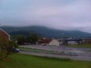
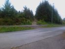
The morning dawned humid and overcast.
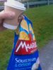
Supplies were purchased.
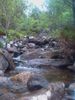
Nice little creek that the initial path passed by.
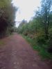
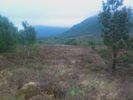
Up the hill...
Then the path looked like it was getting a little more rustic.
Until I realised that there was a light fixture on the side of the path - turns out this path is a lit trail for wintertime cross-country skiing. Huh.
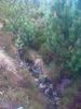
Now we're off trail for the last 400m or so. The little creek doesn't look like much, until I realise that there's one every 6 feet. This place was not so great the day after a rainfall!
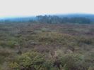
Okay, made it! This looks Northwest.
North.
Northeast.
East.
Down.
Oops, lost the plot there - Uh... South-ish.
Played Solitaire - lost.

Same thing. That's the map of my island.
You can tell how close I am to the road. What you can't tell is how wet my feet are.

I'm pretty sure this qualifies as "stupidly grinning" - That's me. (AshleyMorton)

So does this, but this time I'm wearing a Norwegian sweater.


