Difference between revisions of "2008-06-04 61 -149"
From Geohashing
imported>Maximus (New page: {{meetup graticule |map=<map lat="61" lon="-149" date="2008-06-04" /> |lat=61 |lon=-149 |date=2008-06-4 }} == Logistics == * [http://maps.google.com/maps?q=61.18029229786871545,-149.84503...) |
imported>FippeBot m (Location) |
||
| (20 intermediate revisions by 7 users not shown) | |||
| Line 4: | Line 4: | ||
|lon=-149 | |lon=-149 | ||
|date=2008-06-4 | |date=2008-06-4 | ||
| + | | graticule_name=Anchorage, AK | ||
| + | | graticule_link=Anchorage, Alaska | ||
}} | }} | ||
| + | |||
| + | [[Image:2008-06-04_61_-49.JPG|thumb|300px|Streetview approximation]] | ||
== Logistics == | == Logistics == | ||
* [http://maps.google.com/maps?q=61.18029229786871545,-149.8450323290648286 Google Maps link] | * [http://maps.google.com/maps?q=61.18029229786871545,-149.8450323290648286 Google Maps link] | ||
| − | * In undeveloped land just off Tudor | + | * In undeveloped land just off Tudor, west of Lake Otis, in protected wetlands. The second most accessible location since the algorithm was published. |
| − | |||
== Intended attendees == | == Intended attendees == | ||
| − | * [[User:Maximus| | + | * [[User:Maximus|Max]] and a few friends plan to be there sometime around 8pm. |
| + | * [[User:Yos|Yos]] will be swinging by after work. | ||
== Execution/aftermath == | == Execution/aftermath == | ||
| + | * [[User:Yos|Yos]], [[User:Doug|Doug]] and I ([[User:orbatos|orbatos]]) dropped by at 1700 after work, taking the long route into the bog and being followed by a disheveled (homeless?) man through the woods. We came from the east in an attempt to get closer to the actual location than the roadside access would seem to allow, to no avail. Instead we encountered deep bog strewn with bear and moose sign, as well as an oddity in the form of decorative flowers freshly cut and bound together, soaking in the tepid water. The location is roughly .7 km from my house (this should earn me a Honorable Mention in the [[Couch_Potato_Geohash|Couch Potato Achievement]]). The mosquitoes were ridiculous and my camera malfunctioned, leaving me with only a couple of pictures. | ||
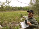
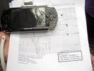
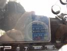
| + | == Photographic Evidence == | ||
| − | == | + | <gallery caption="Yos, Doug, and Orbatos' Expedition" widths="150px" heights="100px" perrow="3"> |
| + | Image:CIMG8160sm.JPG | ||
| + | Image:CIMG8159sm.JPG | ||
| + | Image:CIMG8158sm.JPG | ||
| + | </gallery> | ||
[[Category:Expeditions]] | [[Category:Expeditions]] | ||
[[Category:Expeditions with photos]] | [[Category:Expeditions with photos]] | ||
| + | [[Category:Coordinates not reached]] | ||
| + | [[Category:Not reached - Mother Nature]] | ||
| + | {{location|US|AK|AN}} | ||
Latest revision as of 12:59, 28 July 2019
| Wed 4 Jun 2008 in Anchorage, AK: 61.1802923, -149.8450323 geohashing.info google osm bing/os kml crox |

Logistics
- Google Maps link
- In undeveloped land just off Tudor, west of Lake Otis, in protected wetlands. The second most accessible location since the algorithm was published.
Intended attendees
Execution/aftermath
- Yos, Doug and I (orbatos) dropped by at 1700 after work, taking the long route into the bog and being followed by a disheveled (homeless?) man through the woods. We came from the east in an attempt to get closer to the actual location than the roadside access would seem to allow, to no avail. Instead we encountered deep bog strewn with bear and moose sign, as well as an oddity in the form of decorative flowers freshly cut and bound together, soaking in the tepid water. The location is roughly .7 km from my house (this should earn me a Honorable Mention in the Couch Potato Achievement). The mosquitoes were ridiculous and my camera malfunctioned, leaving me with only a couple of pictures.
Photographic Evidence
- Yos, Doug, and Orbatos' Expedition