Difference between revisions of "2008-06-06 42 -71"
imported>Ahecht (→Expeditions) |
imported>Ahecht (→Expeditions) |
||
| Line 12: | Line 12: | ||
==Expeditions== | ==Expeditions== | ||
| − | [[User:Ahecht|AHecht]] | + | ===[[User:Ahecht|AHecht]] 1:15pm EDT=== |
| + | I didn't find out the coordinated until I was already at work, so I had to make due with what I had with me. I didn't have a camera or separate GPS, so I had to use my phone as a camera and GPS unit (using a bluetooth GPS radio). I put on my emergency rain pants and waterproof boots from my car and headed out. The easiest access to the cache was through a backyard that was nicely mowed all the way to the river. However, not wanting to tresspass, I bushwacked my way down to the banks of the Souhegan. | ||
| + | |||
| + | <gallery caption="Sneaking About" widths="200px" heights="200px" perrow="3"> | ||
| + | Image:Rivercrossing.jpg|The driveway from which the hash was accessible. | ||
| + | Image:2008-06-05-42-71-02.jpg|The rather impressive house associated with the hash location. We knocked on the door to ask for permission to poke about, but nobody was home. | ||
| + | Image:2008-06-05-42-71-03.jpg|We decided to take a quick look around anyway. Soon enough, we reached the hash. This is the satellite photo of the hash, at the hash; stunning resemblance, no? | ||
| + | Image:2008-06-05-42-71-04.jpg|The large field (lawn?) we crossed to reach the hash. | ||
| + | Image:2008-06-05-42-71-05.jpg|Ben at the hash. | ||
| + | Image:2008-06-05-42-71-06.jpg|Grace at the hash. | ||
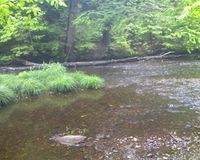
| + | Image:2008-06-05-42-71-07.jpg|There was also a pond nearby, presumably constructed by the local denizens. It looked more like a visual accoutrement than a place one would actually swim in. | ||
| + | </gallery> | ||
| + | |||
[[Category: Meetup on 2008-06-06]] | [[Category: Meetup on 2008-06-06]] | ||
[[Category: Meetup in 42 -71]] | [[Category: Meetup in 42 -71]] | ||
Revision as of 19:10, 6 June 2008
| Fri 6 Jun 2008 in 42,-71: 42.7596630, -71.8253824 geohashing.info google osm bing/os kml crox |
About
This hash is located between Greenville, NH and New Ipswich, NH in the Boston, Massachusetts graticle across the Souhegan River from Rte 123.
Expeditions
AHecht 1:15pm EDT
I didn't find out the coordinated until I was already at work, so I had to make due with what I had with me. I didn't have a camera or separate GPS, so I had to use my phone as a camera and GPS unit (using a bluetooth GPS radio). I put on my emergency rain pants and waterproof boots from my car and headed out. The easiest access to the cache was through a backyard that was nicely mowed all the way to the river. However, not wanting to tresspass, I bushwacked my way down to the banks of the Souhegan.
- Sneaking About
The driveway from which the hash was accessible.
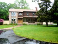
The rather impressive house associated with the hash location. We knocked on the door to ask for permission to poke about, but nobody was home.
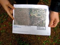
We decided to take a quick look around anyway. Soon enough, we reached the hash. This is the satellite photo of the hash, at the hash; stunning resemblance, no?
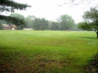
The large field (lawn?) we crossed to reach the hash.

Ben at the hash.
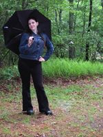
Grace at the hash.
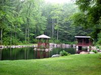
There was also a pond nearby, presumably constructed by the local denizens. It looked more like a visual accoutrement than a place one would actually swim in.


