Difference between revisions of "2008-06-07 31 -97"
From Geohashing
(→The Meetup) |
imported>Thomcat (Success/failure category added) |
||
| Line 15: | Line 15: | ||
| − | <gallery caption="Photo Gallery" widths="200px" heights="200px" perrow=" | + | <gallery caption="Photo Gallery" widths="200px" heights="200px" perrow="2"> |
Image:2008-06-07_31_-97_fromtheroad.jpg|Looking towards the corn field from the road | Image:2008-06-07_31_-97_fromtheroad.jpg|Looking towards the corn field from the road | ||
Image:2008-06-07_31_-97_gettingcloser.jpg|Hiking towards the corn field | Image:2008-06-07_31_-97_gettingcloser.jpg|Hiking towards the corn field | ||
| Line 25: | Line 25: | ||
| − | [[Category: | + | [[Category:Expeditions]] |
| − | [[Category: | + | [[Category:Expeditions with photos]] |
| + | [[Category:Coordinates reached]] | ||
Revision as of 17:31, 7 August 2008
| Sat 7 Jun 2008 in 31,-97: 31.5017842, -97.1143708 geohashing.info google osm bing/os kml crox |
About
This hash was located East of Loop 340 in Waco, TX. GPS: (31.501784N, 97.114371W)
Weather was hot (95°F) and sunny.
The Meetup
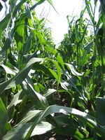
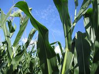
User GreyGndalf and myself hiked out 100 yards into the middle of a corn field on the outskirts of Waco, TX. Walking against the grain of a corn field is not as easy as one might think! We looked around for quite some time for other geohashers in the corn field with no luck. They must have been hiding.
- Photo Gallery
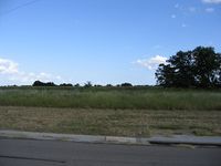
Looking towards the corn field from the road

Hiking towards the corn field
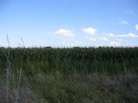
Across the barbed wire and on to the geohash!
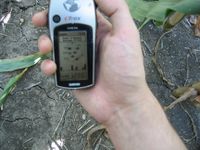
Blurry shot of the GPS at the geohash location.
Looking North from the location.
Looking (roughly) East from the location.


