Difference between revisions of "2008-06-07 33 -84"
(First Draft) |
imported>FippeBot m (Location) |
||
| (12 intermediate revisions by 3 users not shown) | |||
| Line 1: | Line 1: | ||
| − | I took this route [http://maps.google.com/maps?f=d&hl=en&geocode=11741993314167474992,33.865530,-84.476060%3B6485036990195179351,33.858093,-84.452731%3B8020730021135018007,33.835610,-84.448020%3B886007364518605388,33.822026,-84.443146%3B3717779217845173511,33.800976,-84.418550%3B7362307890009266326,33.781500,-84.396070%3B16563392853069587957,33.779550,-84.388810%3B155322528294451478,33.773780,-84.386400%3B10578414046670325520,33.759683,-84.306937%3B4301917735216476628,33.755463,-84.298012%3B16041612254954774480,33.709660,-84.262816%3B7077115439144143258,33.699272,-84.230466%3B15012376652285394343,33.694745,-84.221068%3B2624687955933115470,33.501783,-84.114372&saddr=Cumberland+Mall,+30339&daddr=Paces+Ferry+Rd+SE+%4033.865530,+-84.476060+to:Paces+Ferry+Rd+NW+%4033.858093,+-84.452731+to:Ridgewood+Rd+NW+%4033.835610,+-84.448020+to:Defoors+Ferry+Rd+NW+%4033.822026,+-84.443146+to:Defoor+Ave+NW+%4033.800976,+-84.418550+to:10th+St+NW+%4033.781500,+-84.396070+to:Spring+St+NW+%4033.779550,+-84.388810+to:3rd+St+NE+%4033.773780,+-84.386400+to:E+Lake+Dr+%4033.759683,+-84.306937+to:Lenore+St+%4033.755463,+-84.298012+to:Rainbow+Dr+%4033.709660,+-84.262816+to:Cocklebur+Rd+%4033.699272,+-84.230466+to:Kelley+Chapel+Rd+%4033.694745,+-84.221068+to:33.665425,-84.21072+to:%2B33%C2%B0+30'+6.42%22,+-84%C2%B0+6'+51.74%22+(33.501784,+-84.114371)&mra=dpe&mrcr=0&mrsp=14&sz=15&via=1,2,3,4,5,6,7,8,9,10,11,12,13,14&dirflg=h&sll=33.677354,-84.212909&sspn=0.032035,0.06506&ie=UTF8&ll=33.710061,-84.287796&spn=0.512355,1.040955&z=11|Route] on my bicycle. I started out about 1:30 and arrived at the destination about 4:05. I spent about 30 minutes sitting in a gas station on the ride down, as the entire ride was in the sun and ambient temperatures were in the | + | {{meetup graticule |
| + | | map=<map lat="33" lon="-84" date="2008-06-07" /> | ||
| + | | lat=33 | ||
| + | | lon=-84 | ||
| + | | date=2008-06-07 | ||
| + | }} | ||
| + | |||
| + | On June 7th, 2008 [[User:ElSupreme|ElSupreme]] found the [[Atlanta, Georgia]] geohash. The location was slightly north of McDonough near GA 155. The actual coordinates were at 33.501784229045°, -84.114370840919°. | ||
| + | |||
| + | == About == | ||
| + | |||
| + | I took this route [http://maps.google.com/maps?f=d&hl=en&geocode=11741993314167474992,33.865530,-84.476060%3B6485036990195179351,33.858093,-84.452731%3B8020730021135018007,33.835610,-84.448020%3B886007364518605388,33.822026,-84.443146%3B3717779217845173511,33.800976,-84.418550%3B7362307890009266326,33.781500,-84.396070%3B16563392853069587957,33.779550,-84.388810%3B155322528294451478,33.773780,-84.386400%3B10578414046670325520,33.759683,-84.306937%3B4301917735216476628,33.755463,-84.298012%3B16041612254954774480,33.709660,-84.262816%3B7077115439144143258,33.699272,-84.230466%3B15012376652285394343,33.694745,-84.221068%3B2624687955933115470,33.501783,-84.114372&saddr=Cumberland+Mall,+30339&daddr=Paces+Ferry+Rd+SE+%4033.865530,+-84.476060+to:Paces+Ferry+Rd+NW+%4033.858093,+-84.452731+to:Ridgewood+Rd+NW+%4033.835610,+-84.448020+to:Defoors+Ferry+Rd+NW+%4033.822026,+-84.443146+to:Defoor+Ave+NW+%4033.800976,+-84.418550+to:10th+St+NW+%4033.781500,+-84.396070+to:Spring+St+NW+%4033.779550,+-84.388810+to:3rd+St+NE+%4033.773780,+-84.386400+to:E+Lake+Dr+%4033.759683,+-84.306937+to:Lenore+St+%4033.755463,+-84.298012+to:Rainbow+Dr+%4033.709660,+-84.262816+to:Cocklebur+Rd+%4033.699272,+-84.230466+to:Kelley+Chapel+Rd+%4033.694745,+-84.221068+to:33.665425,-84.21072+to:%2B33%C2%B0+30'+6.42%22,+-84%C2%B0+6'+51.74%22+(33.501784,+-84.114371)&mra=dpe&mrcr=0&mrsp=14&sz=15&via=1,2,3,4,5,6,7,8,9,10,11,12,13,14&dirflg=h&sll=33.677354,-84.212909&sspn=0.032035,0.06506&ie=UTF8&ll=33.710061,-84.287796&spn=0.512355,1.040955&z=11|Route] on my bicycle. I started out about 1:30 and arrived at the destination about 4:05. I spent about 30 minutes sitting in a gas station on the ride down, as the entire ride was in the sun and ambient temperatures were above 95 degrees F the entire trip. I brought with me a GPS unit, Camera, ~ 4 liters of water (which on arrival I had consumed around 5 liters of water and Gatoraid), a kite, and some filp-flops to walk around in. To my surprise the satellite photo of a field was now occupied by a house and Chevy Tahoe. So I got off my bike, and scattered my stuff out in the shade next to the street, and took a just in case GPS photo. Then I realized I failed to write down the actual coordinates, so phoned my mom for her to relay them to me. Then went wandering into the back yard. Found the spot, after my GPS unit told me to walk into the woods, decided to find it myself. Then I packed everything up and started to ride back. After another stop to fill up with water and Gatoraid and another AC stop I realized that it wasn't the distance or lack of food that was making me feel like crap but rather the insane heat, and lack of shade. So I pulled off, about 15 miles back to my house, in a park and called a ride. Took a nap on a picnic bench. Then about 30 minutes later got picked up and driven home. | ||
| + | |||
| + | This was a successful [[Bicycle Geohash]] as I reached the location by bicycle alone, although I did not return the entire length by bicycle. | ||
| + | |||
| + | == People == | ||
| + | |||
| + | People who reached these coordinates: | ||
| + | |||
| + | * [[User:ElSupreme|ElSupreme]] rode his bicycle 45 miles from Vinings, brought food and water, and bought more on the way down, and arrived around 4:05. | ||
| + | |||
| + | == Gallery == | ||
| + | |||
| + | <gallery caption="Photo Gallery" widths="200px" heights="200px" perrow="3"> | ||
| + | Image:ElSupreme 2008-06-07 Atlanta,GA.jpg|ElSupreme near the location at the street. | ||
| + | Image:Fulcrum 2008-06-07 Atlanta,GA.jpg|"Fulcrum" my trusty Cannondale. | ||
| + | Image:MyStuff 2008-06-07 Atlanta,GA.jpg|My crap that I decided to bike to the location. With kite, which did not get used due to heat and the fact location was no longer a field. | ||
| + | Image:Coordinates 2008-06-07 Atlanta,GA.jpg|My to-do list for Thursday, where I wrote down the coordinates I got over the phone. Photo at the location. | ||
| + | Image:GPS 2008-06-07 Atlanta,GA.jpg|Arrived at the correct location. | ||
| + | Image:Don't Panic 2008-06-07 Atlanta,GA.jpg|I did not panic. Photo at the location. | ||
| + | </gallery> | ||
| + | |||
| + | == Comments == | ||
| + | * I lost over 5 pounds of weight this day. Even though a quick calculation gives me drinking about 25+ lbs of water and other fluids. | ||
| + | * Hyperthermia is some serious stuff, so pay attention to the weather. | ||
| + | |||
| + | [[Category:Expeditions]] | ||
| + | [[Category:Expeditions with photos]] | ||
| + | [[Category:Coordinates reached]] | ||
| + | {{location|US|GA|HY}} | ||
Latest revision as of 04:48, 7 August 2019
| Sat 7 Jun 2008 in 33,-84: 33.5017842, -84.1143708 geohashing.info google osm bing/os kml crox |
On June 7th, 2008 ElSupreme found the Atlanta, Georgia geohash. The location was slightly north of McDonough near GA 155. The actual coordinates were at 33.501784229045°, -84.114370840919°.
Contents
About
I took this route [1] on my bicycle. I started out about 1:30 and arrived at the destination about 4:05. I spent about 30 minutes sitting in a gas station on the ride down, as the entire ride was in the sun and ambient temperatures were above 95 degrees F the entire trip. I brought with me a GPS unit, Camera, ~ 4 liters of water (which on arrival I had consumed around 5 liters of water and Gatoraid), a kite, and some filp-flops to walk around in. To my surprise the satellite photo of a field was now occupied by a house and Chevy Tahoe. So I got off my bike, and scattered my stuff out in the shade next to the street, and took a just in case GPS photo. Then I realized I failed to write down the actual coordinates, so phoned my mom for her to relay them to me. Then went wandering into the back yard. Found the spot, after my GPS unit told me to walk into the woods, decided to find it myself. Then I packed everything up and started to ride back. After another stop to fill up with water and Gatoraid and another AC stop I realized that it wasn't the distance or lack of food that was making me feel like crap but rather the insane heat, and lack of shade. So I pulled off, about 15 miles back to my house, in a park and called a ride. Took a nap on a picnic bench. Then about 30 minutes later got picked up and driven home.
This was a successful Bicycle Geohash as I reached the location by bicycle alone, although I did not return the entire length by bicycle.
People
People who reached these coordinates:
- ElSupreme rode his bicycle 45 miles from Vinings, brought food and water, and bought more on the way down, and arrived around 4:05.
Gallery
- Photo Gallery
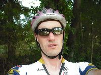
ElSupreme near the location at the street.
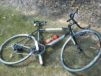
"Fulcrum" my trusty Cannondale.
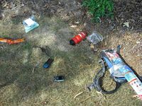
My crap that I decided to bike to the location. With kite, which did not get used due to heat and the fact location was no longer a field.
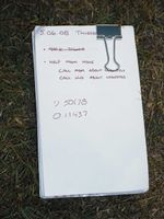
My to-do list for Thursday, where I wrote down the coordinates I got over the phone. Photo at the location.
Arrived at the correct location.
I did not panic. Photo at the location.


Comments
- I lost over 5 pounds of weight this day. Even though a quick calculation gives me drinking about 25+ lbs of water and other fluids.
- Hyperthermia is some serious stuff, so pay attention to the weather.