Difference between revisions of "2008-06-07 37 -122"
From Geohashing
imported>Cwolves |
imported>FippeBot m (Location) |
||
| (4 intermediate revisions by 3 users not shown) | |||
| Line 4: | Line 4: | ||
|lon=-122 | |lon=-122 | ||
|date=2008-06-07 | |date=2008-06-07 | ||
| − | |graticule_name=San Francisco | + | |graticule_name=San Francisco, California |
}} | }} | ||
| Line 11: | Line 11: | ||
== Gallery == | == Gallery == | ||
| − | <gallery caption="Photo Gallery" widths="200px" heights="200px" perrow=" | + | <gallery caption="Photo Gallery" widths="200px" heights="200px" perrow="2"> |
Image:IMG_1206.jpg|View from the middle of the pier | Image:IMG_1206.jpg|View from the middle of the pier | ||
Image:IMG_1209.jpg|View from the middle of the pier | Image:IMG_1209.jpg|View from the middle of the pier | ||
| Line 19: | Line 19: | ||
</gallery> | </gallery> | ||
| − | [http://www.flickr.com/photos/cwolves/sets/72157605528814896/ All of cwolves' photos from this meetup] | + | [http://www.flickr.com/photos/cwolves/sets/72157605528814896/ All of cwolves' public photos from this meetup] |
| + | |||
| + | [[Category:Expeditions]] | ||
| + | [[Category:Expeditions with photos]] | ||
| + | [[Category:Coordinates not reached]] | ||
| + | [[Category:Not reached - Mother Nature]] | ||
| + | {{location|US|CA|SM}} | ||
Latest revision as of 04:49, 7 August 2019
| Sat 7 Jun 2008 in San Francisco, California: 37.5017842, -122.1143708 geohashing.info google osm bing/os kml crox |
Zigdon and Cwolves met at the western end of the bridge, scaled a razorwire fence, and walked on the abandoned pier to get within 700m of the geohash point.
Gallery
- Photo Gallery
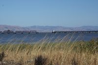
View from the middle of the pier
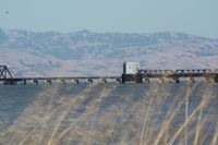
View from the middle of the pier
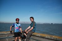
Zigdon & CWolves about 700m from the geohash location
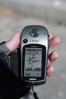
Proof!
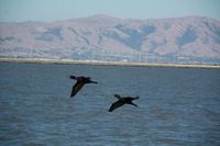
Birdies!


