Difference between revisions of "2008-06-07 39 -76"
imported>Quantumz (→Attendance) |
imported>FippeBot m (Location) |
||
| (5 intermediate revisions by 4 users not shown) | |||
| Line 1: | Line 1: | ||
| − | == | + | {{meetup graticule |
| + | | lat=39 | ||
| + | | lon=-76 | ||
| + | | date=2008-06-07 | ||
| + | | graticule_name=Baltimore | ||
| + | | graticule_link=Baltimore, Maryland | ||
| + | }} | ||
| − | + | == Location == | |
| + | |||
| + | The coordinates are at the very edge of the beach next to what appears to be an Alcohol rehabilitation center. I would presume to state that any visitors should leave Alcohol behind to avoid violent confrontation with the indigenous inhabitants of the site. | ||
39.501784°, -76.114371° | 39.501784°, -76.114371° | ||
| Line 7: | Line 15: | ||
[NOTE] This area does not appear to be fenced off, but may be private property. | [NOTE] This area does not appear to be fenced off, but may be private property. | ||
| − | |||
| − | [[User:quantumz|Zak]] started to go...but | + | == Participants == |
| + | |||
| + | * [User:quantumz|Zak]] | ||
| + | |||
| + | ==Expedition == | ||
| + | |||
| + | [[User:quantumz|Zak]] started to go...but chickened out after several 'No Trespassing' signs. Probably would have been bolder if the site was farther away and I had more invested in reaching the destination. | ||
| − | <gallery caption="080607" widths="200px" heights="200px" perrow=" | + | == Photos == |
| + | |||
| + | <gallery caption="080607" widths="200px" heights="200px" perrow="2"> | ||
Image:080607A.jpg|Entering the Ashley Center. Should have gotten pictures of the road: flanked on either side by a row of tall trees, it was very nice. | Image:080607A.jpg|Entering the Ashley Center. Should have gotten pictures of the road: flanked on either side by a row of tall trees, it was very nice. | ||
| Line 22: | Line 37: | ||
Image:080607E.jpg|By this point I noticed they were nailing signs to any vertical surface, and decided to take my leave of this place. | Image:080607E.jpg|By this point I noticed they were nailing signs to any vertical surface, and decided to take my leave of this place. | ||
</gallery> | </gallery> | ||
| + | |||
| + | [[Category:Expeditions]] | ||
| + | [[Category:Expeditions with photos]] | ||
| + | [[Category:Coordinates not reached]] | ||
| + | [[Category:Not reached - No public access]] | ||
| + | {{location|US|MD|HA}} | ||
Latest revision as of 04:50, 7 August 2019
| Sat 7 Jun 2008 in Baltimore: 39.5017842, -76.1143708 geohashing.info google osm bing/os kml crox |
Contents
Location
The coordinates are at the very edge of the beach next to what appears to be an Alcohol rehabilitation center. I would presume to state that any visitors should leave Alcohol behind to avoid violent confrontation with the indigenous inhabitants of the site.
39.501784°, -76.114371°
[NOTE] This area does not appear to be fenced off, but may be private property.
Participants
- [User:quantumz|Zak]]
Expedition
Zak started to go...but chickened out after several 'No Trespassing' signs. Probably would have been bolder if the site was farther away and I had more invested in reaching the destination.
Photos
- 080607
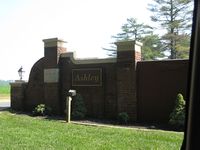
Entering the Ashley Center. Should have gotten pictures of the road: flanked on either side by a row of tall trees, it was very nice.
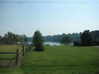
View of the bay through some neighboring houses
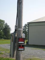
My first sign to leave
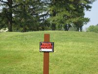
My Second sign to leave
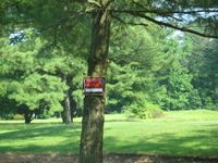
By this point I noticed they were nailing signs to any vertical surface, and decided to take my leave of this place.


