Difference between revisions of "2008-06-10 37 -122"
From Geohashing
imported>Darcy (New page: {{meetup graticule | map=<map lat="37" lon="-122" date="2008-06-10" /> | lat=37 | lon=-122 | date=2008-06-10 | graticule_name=San Francisco | graticule_link=San Francisco, California }} [...) |
imported>FippeBot m (Location) |
||
| (2 intermediate revisions by 2 users not shown) | |||
| Line 15: | Line 15: | ||
(There has got to be a way to set this up so that the pictures don't always show up down ''below'' the graticule image -- I have a small screen, okay?) | (There has got to be a way to set this up so that the pictures don't always show up down ''below'' the graticule image -- I have a small screen, okay?) | ||
| − | + | <br /><br /><br /><br /><br /><br /><br /><br /><br /> | |
<gallery> | <gallery> | ||
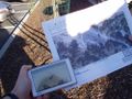
Image:SF-06-10-08-gpsandmap.JPG|They may not quite agree, but it's all about averaging | Image:SF-06-10-08-gpsandmap.JPG|They may not quite agree, but it's all about averaging | ||
| Line 22: | Line 22: | ||
</gallery> | </gallery> | ||
| − | + | [[Category:Expeditions]] | |
[[Category:Expeditions with photos]] | [[Category:Expeditions with photos]] | ||
| − | [[Category: | + | [[Category:Coordinates reached]] |
| + | {{location|US|CA|CN}} | ||
Latest revision as of 04:57, 7 August 2019
| Tue 10 Jun 2008 in San Francisco: 37.8758452, -122.0997684 geohashing.info google osm bing/os kml crox |
Darcy, Mystitat, and Matt (comprising two separate groups) met up somewhere approximating the spot at around 6:50pm. Between the Google Maps image and the car GPS that was set to off-road directions, we know that we at least walked through the spot, even if that wasn't quite where we took the picture.
There was a Little League awards ceremony in progress, so the parking lot was full of mostly SUVs (it was, after all, east of the hills).
Pictures
(There has got to be a way to set this up so that the pictures don't always show up down below the graticule image -- I have a small screen, okay?)
They may not quite agree, but it's all about averaging
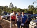
Shiny happy people
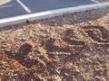
If it had been noon, you'd never have known we were there


