Difference between revisions of "2008-06-11 42 -71"
From Geohashing
imported>Tuttleturtle42 |
m (fix, sorry) |
||
| (4 intermediate revisions by 4 users not shown) | |||
| Line 8: | Line 8: | ||
==The Location== | ==The Location== | ||
| − | + | {{egl|2008-06-11|42|-72|text=Map Coordinates}} | |
The site was in a horses' corral or the woods behind it in Sterling MA. The location itself was not reachable, but the road 500 feet away was. | The site was in a horses' corral or the woods behind it in Sterling MA. The location itself was not reachable, but the road 500 feet away was. | ||
| Line 30: | Line 30: | ||
</gallery> | </gallery> | ||
| + | |||
| + | [[Category:Expeditions]] | ||
| + | [[Category:Expeditions with photos]] | ||
| + | [[Category:Coordinates not reached]] | ||
| + | [[Category:Not reached - No public access]] | ||
| + | [[Category:Expedition without GPS]] | ||
| + | {{location|US|MA|WO}} | ||
Latest revision as of 18:50, 18 January 2022
| Wed 11 Jun 2008 in 42,-71: 42.4657200, -71.7263600 geohashing.info google osm bing/os kml crox |
The Location
The site was in a horses' corral or the woods behind it in Sterling MA. The location itself was not reachable, but the road 500 feet away was.
The Geohash
Judging by distances from Google Maps made getting to this geohash difficult, as the street sign to the road it was off was missing. However after only a mile or two extra, the location was found at around 6 PM by Tuttleturtle42.
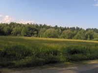
The field across the street from the geohash point.
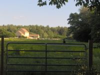
The horse's corral the geohash was estimated to be in.
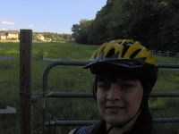
Tuttleturtle42 having reached the location by bike.
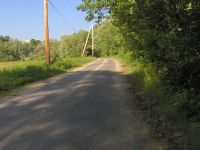
The road the geohash was ~500 feet from.


