Difference between revisions of "2008-06-24 53 9"
From Geohashing
imported>Hermann (New page: {{meetup graticule | map=<map lat="53" lon="9" date="2008-06-24" /> | lat=53 | lon=9 | date=2008-06-24 }} ==About== The coordinates of this geohash are <pre> 53.656855630923445, 9.7411094...) |
imported>Hermann (added geonad link) |
||
| Line 15: | Line 15: | ||
==Expedition== | ==Expedition== | ||
[[User:Hermann|Hermann]] and [[User:Felix|Felix]] were there:<br> | [[User:Hermann|Hermann]] and [[User:Felix|Felix]] were there:<br> | ||
| − | It was a sunny day and medium temperatures. All in all ideal weather for a small bikeride. We reached the fields south from "Appen" without any troubles. As we got closer, the land turned out not to be fallow ground but a swamp covered with reed and nettels. We circumwent the area but didn't find a way to the hash. Therefore, we estimated the [http://maps.google.com/maps?f=q&hl=de&geocode=&q=53.656772,+9.742003&ie=UTF8&ll=53.656736,9.74218&z=18 nearest point] and took our photos there: | + | It was a sunny day and medium temperatures. All in all ideal weather for a small bikeride. We reached the fields south from "Appen" without any troubles. As we got closer, the land turned out not to be fallow ground but a swamp covered with reed and nettels. We circumwent the area but didn't find a way to the hash. Therefore, we [[Geonad|estimated]] the [http://maps.google.com/maps?f=q&hl=de&geocode=&q=53.656772,+9.742003&ie=UTF8&ll=53.656736,9.74218&z=18 nearest point] and took our photos there: |
<gallery heights="200px" widths="250px" caption="Photos"> | <gallery heights="200px" widths="250px" caption="Photos"> | ||
Revision as of 17:26, 25 June 2008
| Tue 24 Jun 2008 in 53,9: 53.6568556, 9.7411095 geohashing.info google osm bing/os kml crox |
About
The coordinates of this geohash are
53.656855630923445, 9.741109459715217
The hash was south "Appen" in a sawmp.
Expedition
Hermann and Felix were there:
It was a sunny day and medium temperatures. All in all ideal weather for a small bikeride. We reached the fields south from "Appen" without any troubles. As we got closer, the land turned out not to be fallow ground but a swamp covered with reed and nettels. We circumwent the area but didn't find a way to the hash. Therefore, we estimated the nearest point and took our photos there:
- Photos
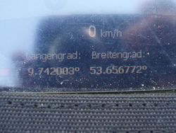
GPS at the photo-location

