Difference between revisions of "2008-06-28 26 -80"
imported>Aperfectring m |
imported>Thomcat (Success/failure category added) |
||
| Line 24: | Line 24: | ||
}} | }} | ||
| − | <gallery> | + | <gallery perrow="3"> |
Image:2008_06_28_apr1.JPG | Near a boat ramp relatively close to the hash point. | Image:2008_06_28_apr1.JPG | Near a boat ramp relatively close to the hash point. | ||
Image:2008_06_28_apr2.JPG | A canal and hammock near the visitor's center. Possibly alligators here! | Image:2008_06_28_apr2.JPG | A canal and hammock near the visitor's center. Possibly alligators here! | ||
| Line 34: | Line 34: | ||
[[Category:Expeditions]] | [[Category:Expeditions]] | ||
| + | [[Category:Expeditions with photos]] | ||
| + | [[Category:Coordinates not reached]] | ||
| + | [[Category:Failed - No public access]] | ||
Revision as of 19:18, 11 August 2008
| Sat 28 Jun 2008 in 26,-80: 26.6581110, -80.3656342 geohashing.info google osm bing/os kml crox |
About
In the Loxahatchee National Wildlife Refuge in the section which is not open to the public.
Expeditions
Aperfectring
Went to the nearest place to the hash that was on public land, about 1.5mi from the location. After that, I went to the visitor's center for the refuge, and took a hike on the boardwalk through the cypress marsh there. I also got a picture of a restricted access sign, which qualifies me for:
Template:No tresspassing geohash
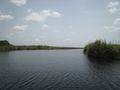
Near a boat ramp relatively close to the hash point.
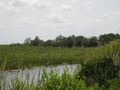
A canal and hammock near the visitor's center. Possibly alligators here!
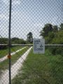
The posted sign preventing access to the hash site.
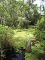
Part of the cypress marshes which make up a part of the refuge.
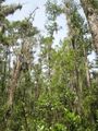
Looking up at the treetops in the cypress marsh.

Aperfectring's ugly mug in the cypress marsh, some 15 mi. from the hash site.


