Difference between revisions of "2008-07-09 40 -112"
From Geohashing
imported>Xaco (→Expeditions) |
imported>Thomcat (Success/failure category added) |
||
| Line 17: | Line 17: | ||
Image:xaco_N40_W112_2008-07-09_02.jpg|Some more of the view | Image:xaco_N40_W112_2008-07-09_02.jpg|Some more of the view | ||
</gallery> | </gallery> | ||
| + | |||
| + | [[Category:Expeditions]] | ||
| + | [[Category:Expeditions with photos]] | ||
| + | [[Category:Coordinates reached]] | ||
Revision as of 03:51, 12 August 2008
| Wed 9 Jul 2008 in 40,-112: 40.5924897, -112.0418876 geohashing.info google osm bing/os kml crox |
About
This geohash is located in the Tooele, Utah graticule in a field just north of a housing development.
Expeditions
xaco got there around 3 pm and found even more of a housing development than was shown on Google maps. For a minute, I thought it was going to be in the middle of a construction area, but it turned out to be just north of there. I ended up parking next to a bunch of half-built houses teeming with construction workers and wandered out into the field.
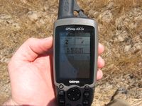
The coordinates
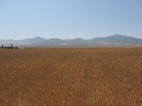
Some of the view
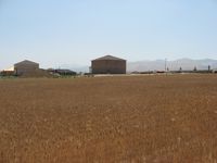
Some more of the view


