Difference between revisions of "2008-07-20 48 11"
From Geohashing
imported>Urac m |
imported>Thomcat (Success/failure category added) |
||
| Line 24: | Line 24: | ||
Image:geo_20080720_48_11_2.jpg | Image:geo_20080720_48_11_2.jpg | ||
</gallery> | </gallery> | ||
| + | |||
| + | [[Category:Expeditions]] | ||
| + | [[Category:Expeditions with photos]] | ||
| + | [[Category:Coordinates reached]] | ||
| + | [[Category:Expedition without GPS]] | ||
Revision as of 14:48, 12 August 2008
| Sun 20 Jul 2008 in 48,11: 48.0894851, 11.7540661 geohashing.info google osm bing/os kml crox |
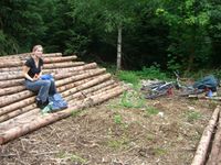
I have been there. (Dragged along my girlfriend.)
16:30 to 17:30
I would have loved to go to [Zillertal] which is in the Innsbruck graticule, but the weather was to uncertain for a motorbike trip.
It was a No Batteries Geohash: All we had was two printed screenshots to find the spot. No GPS. Actually harder than I thought ;-)
The bike trip was nice, but mainly through town (coming from Schwabing). The thrill was the weather... The spot unspectacular, in the woods. Not to hard to find, but since this was my first time and no GPS I got to a wrong location first, but corrected that. Pictures taken a few meters away from the location because trees on photos are not very exiting.
Got home by S-Bahn just before the storm started.
- Photo Gallery