Difference between revisions of "2008-07-23 52 7"
imported>Benjw m (→Achievements: missing apostrophe) |
imported>FippeBot m (Location) |
||
| (One intermediate revision by one other user not shown) | |||
| Line 1: | Line 1: | ||
{{meetup graticule | {{meetup graticule | ||
| − | |||
| lat=52 | | lat=52 | ||
| lon=7 | | lon=7 | ||
| Line 10: | Line 9: | ||
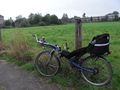
Took the graticule's [[Virgin_Graticule|virginity]]. [[Bicycle_Geohash|Cycled]] there. [[Border geohash|Border]] crossed. Arvid is not sure if crossing a frontier under the [http://en.wikipedia.org/wiki/Schengen_Agreement Schengen agreement] should count though. | Took the graticule's [[Virgin_Graticule|virginity]]. [[Bicycle_Geohash|Cycled]] there. [[Border geohash|Border]] crossed. Arvid is not sure if crossing a frontier under the [http://en.wikipedia.org/wiki/Schengen_Agreement Schengen agreement] should count though. | ||
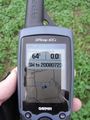
| − | The hashpoint wasn't | + | The hashpoint wasn't where [[User:Arvid|Arvid]] looked for it. The GPS was on the Dutch datum, whatever that may be. It's on WGS84 now. The hashpoint was somewhere in the middle of the field (like google shows). I could've made a perfect hash! |
==Expedition== | ==Expedition== | ||
| Line 28: | Line 27: | ||
Image:20080723 52 7-RES01297.JPG|Awesome weather | Image:20080723 52 7-RES01297.JPG|Awesome weather | ||
Image:20080723 52 7-RES01298.JPG|No wind though | Image:20080723 52 7-RES01298.JPG|No wind though | ||
| − | Image:20080723 52 7-RES01302.JPG|View from as close as | + | Image:20080723 52 7-RES01302.JPG|View from as close as I got to the point of the hash to the road |
Image:20080723 52 7-RES01307.JPG|View from the road to the hashpoint | Image:20080723 52 7-RES01307.JPG|View from the road to the hashpoint | ||
Image:20080723 52 7-RES02300.JPG|About as close as I got. Still about 30m to go... | Image:20080723 52 7-RES02300.JPG|About as close as I got. Still about 30m to go... | ||
| Line 43: | Line 42: | ||
[[Category:Expeditions with photos]] | [[Category:Expeditions with photos]] | ||
[[Category:Coordinates not reached]] | [[Category:Coordinates not reached]] | ||
| + | [[Category:Not reached - Technology]] | ||
| + | {{location|DE|NW|ST}} | ||
Latest revision as of 06:04, 7 August 2019
| Wed 23 Jul 2008 in 52,7: 52.2130408, 7.1882042 geohashing.info google osm bing/os kml crox |
Achievements
Took the graticule's virginity. Cycled there. Border crossed. Arvid is not sure if crossing a frontier under the Schengen agreement should count though. The hashpoint wasn't where Arvid looked for it. The GPS was on the Dutch datum, whatever that may be. It's on WGS84 now. The hashpoint was somewhere in the middle of the field (like google shows). I could've made a perfect hash!
Expedition
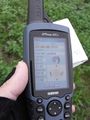
Arvid's tracklog showing where he thought the hash was, and where the hash actually was.
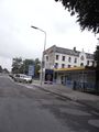
This one looked rather close, and since it also looked like it was in some field in town next to a hospital, it looked very reachable. The bad part was the cycling route is 60-70% in town, but the total distance(42km) is a good morning workout for me. The weather was not that good though. About 13-15C, 98% humidity when I left. Water in the air even suffered a bit from gravity.
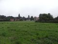
The hashpoint itself was a bit further than the extreme corner of the field, which indeed was just a field of grass in town. There were some homes for old people next to it. Very convenient, next to the hospital. The field was wet, and my cycling shoes aren't waterproof.
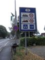
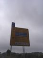
Entering Germany
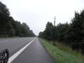
Awesome weather
No wind though
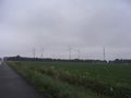
View from as close as I got to the point of the hash to the road
View from the road to the hashpoint
About as close as I got. Still about 30m to go...
I was there at 10am local time (CEST)
Distance cycled
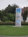
The hashpoint was next to the hospital
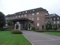
Hospital
Still awesome weather on the way back
Entering the Netherlands again


