Difference between revisions of "2008-07-25 52 13"
imported>ReletBot m (Failed => Not reached) |
imported>ReletBot m (Automatically appending gallery for one of relet's expeditions.) |
||
| Line 24: | Line 24: | ||
[[Category:Coordinates not reached]] | [[Category:Coordinates not reached]] | ||
[[Category:Not reached - No public access]] | [[Category:Not reached - No public access]] | ||
| + | |||
| + | == Gallery == | ||
| + | <gallery widths="160px" align=center> | ||
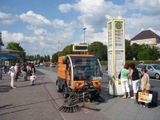
| + | Image:200807255213-P1010720.JPG|lyx and relet @ S+U Spandau | ||
| + | Image:200807255213-P1010719.JPG|not public transport | ||
| + | Image:200807255213-P1010721.JPG|no trespassing | ||
| + | Image:200807255213-P1010722.JPG|Stupid Grin | ||
| + | Image:200807255213-P1010724.JPG|at the entry to the reserve | ||
| + | Image:200807255213-P1010725.JPG|lake Krampnitz, from afar | ||
| + | </gallery> | ||
Revision as of 01:33, 1 July 2009

| Fri 25 Jul 2008 in 52,13: 52.4611341, 13.0635047 geohashing.info google osm bing/os kml crox |
We went for the public transport achievement to reach todays geohash near Krampnitz in the lake district east of Berlin. What we got on top was the no trespassing achievement. Our maps showed the area of the hash to be a forest, with a restricted area close by. However, the closest service road was barred with a boom and labeled as nature reserve and former military area. As we were in a bit of a rush, we decided not to enter the forest and left with a Stupid Grin[tm].
- lyx and relet @ S+U Spandau
- not public transport
- no trespassing^1
- Stupid Grin
- at the entry to the reserve
- lake Krampnitz, from afar
^1: The sign actually says that trespassing would be allowed on marked paths. That still means that we wouldn't have been able to reach the hash in the middle of the wood. As we weren't sure if the service path with the boom was marked or not, we decided not to trespass here.
Gallery

lyx and relet @ S+U Spandau
not public transport
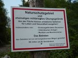
no trespassing
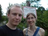
Stupid Grin
at the entry to the reserve
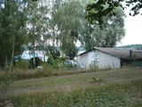
lake Krampnitz, from afar


