Difference between revisions of "2008-08-09 40 -88"
From Geohashing
imported>Brettdaniel (Create Page) |
imported>Brettdaniel (Captions) |
||
| Line 9: | Line 9: | ||
<gallery perrow="2"> | <gallery perrow="2"> | ||
| − | Image:2008-08-09 40 -88 gps.jpg | + | Image:2008-08-09 40 -88 gps.jpg | Brett's GPS showing his arrival |
| − | Image:2008-08-09 40 -88 field.jpg | + | Image:2008-08-09 40 -88 field.jpg | The field containing the coordinates |
| − | Image:2008-08-09 40 -88 bike and power line.jpg | + | Image:2008-08-09 40 -88 bike and power line.jpg | Brett's bike |
| − | Image:2008-08-09 40 -88 flag.jpg | + | Image:2008-08-09 40 -88 flag.jpg | The flag marking the coordinates |
| − | Image:2008-08-09 40 -88 donkeys.jpg | + | Image:2008-08-09 40 -88 donkeys.jpg | Donkeys near the coordinates |
</gallery> | </gallery> | ||
Revision as of 00:46, 10 August 2008
| Sat 9 Aug 2008 in 40,-88: 40.0913829, -88.0585948 geohashing.info google osm bing/os kml crox |
The coordinates fell just 11 miles east of Champaign. Brett biked from the University of Illinois campus, arriving at the coordinates around 4:15. The coordinates fell in (surprise!) a soybean field. Brett rested there for a while, but no one else showed up. He left a bright pink flag marking the spot. He then biked through nearby St. Joseph, Illinois (pop. 2,300) where he found a small neighborhood festival. After that, he retraced his path back to Champaign.
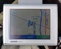
Brett's GPS showing his arrival
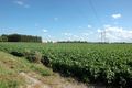
The field containing the coordinates
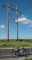
Brett's bike
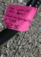
The flag marking the coordinates
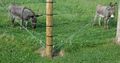
Donkeys near the coordinates


