Difference between revisions of "2008-08-10 47 -65"
From Geohashing
imported>Wmcduff m (→Expiditions: Spelling) |
imported>Wmcduff (Pictures from the hash!) |
||
| Line 14: | Line 14: | ||
===[[User:wmcduff|wmcduff]]=== | ===[[User:wmcduff|wmcduff]]=== | ||
| − | + | Made the attempt. Pictures up, write-up to follow! | |
| − | [[Category: | + | <gallery perrow="3"> |
| + | Image:2008-08-10 47 -65 Nice day.jpg|Blue up there? Not grey or black? Quelle surprise, a nice day! | ||
| + | Image:2008-08-10 47 -65 Check map.jpg|Screen capped last night, I printed out some maps for myself. | ||
| + | Image:2008-08-10 47 -65 Corner of Source and Frenette.jpg|The corner just to the northeast of the coordinates. | ||
| + | Image:2008-08-10 47 -65 Access road?.jpg|A road? Long driveway? Can't see a no tresspassing sign... | ||
| + | Image:2008-08-10 47 -65 Bush hash.jpg|The coordinates, or at least pretty close...I need a GPS. | ||
| + | </gallery> | ||
| + | |||
| + | [[Category:Expeditions with photos]] | ||
| + | [[Category:Coordinates reached]] | ||
Revision as of 20:25, 10 August 2008
| Sun 10 Aug 2008 in Bathurst: 47.7371241, -65.7374328 geohashing.info google osm bing/os kml crox |
About
The hashpoint will be on land in western Nigadoo, just east of the highway. The area has road access 250 feet away, which suggests a backyard.
Expeditions
wmcduff
Made the attempt. Pictures up, write-up to follow!
Blue up there? Not grey or black? Quelle surprise, a nice day!
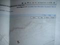
Screen capped last night, I printed out some maps for myself.
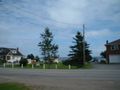
The corner just to the northeast of the coordinates.
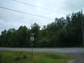
A road? Long driveway? Can't see a no tresspassing sign...
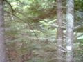
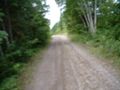
The coordinates, or at least pretty close...I need a GPS.


