Difference between revisions of "2008-08-11 32 -80"
imported>Coreycubed (New page: {{meetup graticule | map=<map lat="32" lon="-80" date="2008-08-11" /> | lat=32 | lon=-80 | date=2008-08-11 | graticule_name=Beaufort | graticule_link=Beaufort, South Carolina}} ==About== ...) |
imported>Coreycubed |
||
| Line 20: | Line 20: | ||
<gallery> | <gallery> | ||
| − | Image:2008-08-11_site.jpg | + | Image:2008-08-11_site.jpg|Approaching the site |
| − | Image:2008-08-11_geohash.jpg | + | Image:2008-08-11_geohash.jpg|Picture of the geohash itself |
| − | Image:2008-08-11_coreycubed.jpg | + | Image:2008-08-11_coreycubed.jpg|About as close as [[User:Coreycubed|Coreycubed]] is going to get to that water |
</gallery> | </gallery> | ||
Revision as of 23:53, 11 August 2008
| Mon 11 Aug 2008 in Beaufort: 32.9608377, -80.0313900 geohashing.info google osm bing/os kml crox |
About
Located in Otranto, a small suburb of North Charleston (which is nowhere near Beaufort). In the extreme NE corner of the graticule, about 100 feet offshore into the Goose Creek Reservoir.
Expeditions
Coreycubed
The geohash is only about two miles from my house. It was located about 100 feet from shore; the water was coated in algae and various kinds of muck. The resident of the property adjacent to the reservoir also warned of alligators. We attempted to get closer to the actual site but he had just finished boating and was ready to put the boat away. We snapped a few pictures from the shore before heading back.
As the first geohash reached in the Beaufort, South Carolina graticule, this makes Coreycubed eligible for the Virgin Graticule achievement.
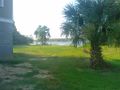
Approaching the site
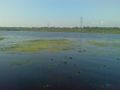
Picture of the geohash itself
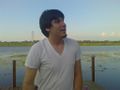
About as close as Coreycubed is going to get to that water


Next time, I'll try to get a better GPS fix on-site.