Difference between revisions of "2008-08-16 50 -119"
From Geohashing
imported>Juventas |
m |
||
| (9 intermediate revisions by 5 users not shown) | |||
| Line 6: | Line 6: | ||
| graticule_name=Vernon, British Columbia | | graticule_name=Vernon, British Columbia | ||
| graticule_link=Vernon, British Columbia | | graticule_link=Vernon, British Columbia | ||
| + | }} | ||
| + | |||
| + | ==Participants== | ||
| + | *[[User:Juventas|Juventas]] | ||
| + | |||
| + | ==Ribbons== | ||
| + | |||
| + | {{There might be alligators! | ||
| + | | latitude = 50 | ||
| + | | longitude = -119 | ||
| + | | date = 2008-08-16 | ||
| + | | name = Juventas | ||
| + | | hazard = underground stream | ||
| + | | image = 2008-08-16_hole.jpg | ||
}} | }} | ||
| Line 17: | Line 31: | ||
[[Category:Expeditions]] | [[Category:Expeditions]] | ||
[[Category:Expeditions with photos]] | [[Category:Expeditions with photos]] | ||
| − | [[Category: | + | [[Category:Not reached - Mother Nature]] |
| + | [[Category:Coordinates not reached]] | ||
| + | {{location|CA|BC|NO}} | ||
Latest revision as of 17:00, 19 March 2022
| Sat 16 Aug 2008 in Vernon, British Columbia: 50.3351359, -119.6121764 geohashing.info google osm bing/os kml crox |
Participants
Ribbons
Juventas earned the There might be alligators! consolation prize
|
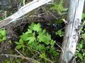
The hole of doom
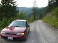
Windy road
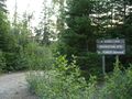
Site entrance
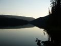
Bouleau Lake


