Difference between revisions of "2008-08-27 48 -122"
imported>Thomcat m |
imported>FippeBot m (Location) |
||
| Line 45: | Line 45: | ||
[[Category:Expeditions with photos]] | [[Category:Expeditions with photos]] | ||
[[Category:Coordinates reached]] | [[Category:Coordinates reached]] | ||
| + | {{location|US|WA|SN}} | ||
Latest revision as of 06:40, 7 August 2019
| Wed 27 Aug 2008 in Bellingham: 48.0265997, -122.1961107 geohashing.info google osm bing/os kml crox |
Contents
About
The geohash is on Smith Island, between Steamboat Slough and the Snohomish River. There seems to be a narrow road or path running just west of the point.
Participants
Expeditions
Thomcat
I had to wend my way through construction vehicles loading and unloading dirt, gravel, and cement. Eventually I reached a causeway and parked to walk.
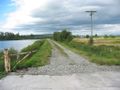
The geohash is to the right.

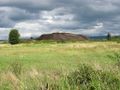
I set my sights on the large mound of dirt visible from the causeway. I crossed the cattails and a small wet ditch, somehow managing to stay dry, and eventually reached the point. My GPS needs a little calibration, apparently - I sure didn't feel like I was 11.3 feet below sea level.
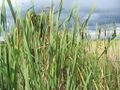

Had to dodge these
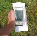
11.3 feet!


Making my way back out of the site, I was stopped by a train. This gave me a few minutes to sit and contemplate a geohash gone well, and quite possibly the first successful land hash in this graticule. My research continues...

