Difference between revisions of "2008-09-02 39 -87"
From Geohashing
imported>Brettdaniel |
imported>ReletBot m (Failed => Not reached) |
||
| Line 14: | Line 14: | ||
Image:2008-09-02 39 87 flag.jpg | The flag marking the coordinates | Image:2008-09-02 39 87 flag.jpg | The flag marking the coordinates | ||
</gallery> | </gallery> | ||
| − | |||
[[Category:Expeditions]] | [[Category:Expeditions]] | ||
[[Category:Expeditions with photos]] | [[Category:Expeditions with photos]] | ||
[[Category:Coordinates not reached]] | [[Category:Coordinates not reached]] | ||
| − | [[Category: | + | [[Category:Not reached - Mother Nature]] |
Revision as of 20:24, 31 March 2009
| Tue 2 Sep 2008 in 39,-87: 39.9290373, -87.9681321 geohashing.info google osm bing/os kml crox |
The coordinates fell in the far northwest corner of the graticule. Brett, who is normally based in Champaign/Urbana, Illinois, detoured to within about half a mile of the coordinates while on his way to Indianapolis, Indiana. He arrived at sunset. Since it was rapidly getting dark, Brett did not hike into the cornfield containing the precise point. However, he did leave a flag marking the point closest to the road.
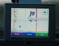
Brett's GPS showing his closest approach
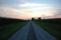
The sun setting
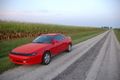
Brett's car at the side of the road
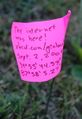
The flag marking the coordinates


