Difference between revisions of "2008-09-06 32 -117"
From Geohashing
imported>Cliffhopper (Created page with 'File:Example.jpg{{meetup graticule | map=<map lat="32" lon="-117" date="2008-09-06" /> | lat=32 | lon=-117 | date=2008-09-06 | graticule_name=San Diego | graticule_link=San D…') |
imported>FippeBot m (Location) |
||
| (6 intermediate revisions by one other user not shown) | |||
| Line 1: | Line 1: | ||
| − | + | {{meetup graticule | |
| map=<map lat="32" lon="-117" date="2008-09-06" /> | | map=<map lat="32" lon="-117" date="2008-09-06" /> | ||
| lat=32 | | lat=32 | ||
| Line 9: | Line 9: | ||
| − | I, [[user:Cliffhopper]], went to check out this geohash. | + | I, [[user:Cliffhopper|Cliffhopper]], went to check out this geohash. Google maps showed the hash in a business park parking lot. |
I got to the business park around 11:50 and found myself in an adjacent lot. I got out of my car and walked to the correct lot. I took pictures of my iphone's google map, the parking lot, driveway, and a tree opposite the lot. It looked like they were paving that day. I did not expect to see anyone else there, so I left around 12:00. | I got to the business park around 11:50 and found myself in an adjacent lot. I got out of my car and walked to the correct lot. I took pictures of my iphone's google map, the parking lot, driveway, and a tree opposite the lot. It looked like they were paving that day. I did not expect to see anyone else there, so I left around 12:00. | ||
| − | + | <gallery caption="Photo Gallery" widths="200px" heights="200px" perrow="2"> | |
| + | Image:2008-09-06 32 -117 geohash.jpg|Location | ||
| + | Image:2008-09-06 32 -117 tree.jpg|The tree | ||
| + | Image:2008-09-06 32 -117 driveway.jpg|The driveway | ||
| + | Image:2008-09-06 32 -117 lot.jpg|The parking lot | ||
| + | </gallery> | ||
| Line 20: | Line 25: | ||
[[Category:Expeditions with photos]] | [[Category:Expeditions with photos]] | ||
[[Category:Coordinates reached]] | [[Category:Coordinates reached]] | ||
| + | {{location|US|CA|SD}} | ||
Latest revision as of 06:50, 7 August 2019
| Sat 6 Sep 2008 in San Diego: 32.8999133, -117.1865472 geohashing.info google osm bing/os kml crox |
I, Cliffhopper, went to check out this geohash. Google maps showed the hash in a business park parking lot.
I got to the business park around 11:50 and found myself in an adjacent lot. I got out of my car and walked to the correct lot. I took pictures of my iphone's google map, the parking lot, driveway, and a tree opposite the lot. It looked like they were paving that day. I did not expect to see anyone else there, so I left around 12:00.
- Photo Gallery
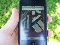
Location
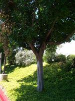
The tree
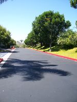
The driveway
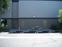
The parking lot


