Difference between revisions of "2008-09-12 47 -121"
From Geohashing
imported>HarlequinsDad (→HarlequinsDad) |
imported>Robyn (Categories for a successful expedition) |
||
| Line 14: | Line 14: | ||
Image:2008_09_12_47_-121_H.jpg|...and that's Harlequin. | Image:2008_09_12_47_-121_H.jpg|...and that's Harlequin. | ||
</gallery> | </gallery> | ||
| + | [[Category:Meetup in 47 -121]] | ||
| + | [[Category:Meetup on 2008-09-12]] | ||
| + | [[Category:Coordinates reached]] | ||
| + | [[Category:Expeditions with photos]] | ||
Revision as of 22:58, 26 September 2008
About
Just off of Cedar Falls Rd., behind the transfer station.
Expeditions
HarlequinsDad
I was at Rattlesnake Lake less that a mile up the road during the day participating in the eradication of non-native plants (blackberries). Afterward, I checked out the hash location from my car and could get within 0.07 miles parked by the recycling bins at the bottom of the transfer station. Later, I picked up Harlequin and we went back. This time we hiked through the brush to get behind the transfer station and made the location as exactly as my GPS would allow.
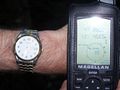
We're here!
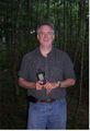
That's me...
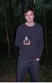
...and that's Harlequin.


