Difference between revisions of "2008-09-20 49 9"
imported>Danatar (Page created with my story) |
imported>Danatar m |
||
| Line 6: | Line 6: | ||
| graticule_name=Würzburg, Germany | | graticule_name=Würzburg, Germany | ||
| graticule_link=Würzburg, Germany | | graticule_link=Würzburg, Germany | ||
| − | }} | + | }}== Location == |
| − | |||
| − | == Location == | ||
Today's location is in a sugar beet field near the village of Vilchband. The hashpoint is in the state Baden-Württemberg, about 350 meters west of the state border to Bavaria (This is not important at all, but you might wonder about the dashed line on the map). | Today's location is in a sugar beet field near the village of Vilchband. The hashpoint is in the state Baden-Württemberg, about 350 meters west of the state border to Bavaria (This is not important at all, but you might wonder about the dashed line on the map). | ||
| Line 40: | Line 38: | ||
[[Category:Expedition without GPS]] | [[Category:Expedition without GPS]] | ||
[[Category:Coordinates reached]] | [[Category:Coordinates reached]] | ||
| + | [[Category:Danatar]] | ||
Revision as of 23:31, 8 November 2008
| Sat 20 Sep 2008 in Würzburg, Germany: 49.5939233, 9.8365649 geohashing.info google osm bing/os kml crox |
Location
Today's location is in a sugar beet field near the village of Vilchband. The hashpoint is in the state Baden-Württemberg, about 350 meters west of the state border to Bavaria (This is not important at all, but you might wonder about the dashed line on the map).
Expedition (Danatar)
Wow, a Saturday hashpoint in by bike reachable distance, even though "reachable distance" in this case means "farther than I would voluntarily go" and though I am expecting guests for dinner! Getting easily addicted to useless but funny things like geohashing, I really had no choice, I had to go there.
Armed with a map printout, directions and supplies (water, chocolate), I mounted my bike and set out for the countryside. The road google had chosen for me turned out to be a medium traffic country road without any bicycle lane, but luckily nobody run me over. It was going mostly uphill with the steepest slope shortly before the hashpoint, but I had no real problems getting there. I arrived at the dirt track next to the hashpoint at 3:55 p.m. and used some guessing (and counting steps) to find the right spot. Then, after a detour around a ditch, I took some steps into the field (the sugar beets have enough space between them) and started to document my success. As expected, nobody else showed up.
On my way back, I was happy to be able to go downhill so much, because I haven't cycled more than 30 kilometers in one day for years and my legs were getting really heavy. My bar of chocolate was the thing that kept me going. I had to eat three bites for every kilometer, but it took the weariness away and gave me enough energy (no, it was a normal chocolate bar with no added "spices") to get home in time to finish the onion tart for my guests. Distance cycled: 29.7 km there + 30.5 km back = 60.2 km total
Nobody seems to have visited this graticule before. Proof that I went by bike (photo 3) to the correct location (photos 1 to 3) can be taken from the gallery (I'm still watching eBay for a GPS).
Danatar earned the Bicycle geohash achievement
|
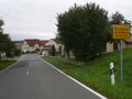
1) Vilchband town sign

2) Coordinates reached, including Stupid Grintm
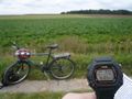
3) Date & time, means of transport, hashpoint area
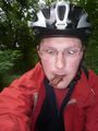
4) My head feels so light, does this mean not enough sugar or too much of it? Ba-ba-doodle-doo...
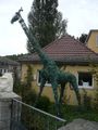
Africa is not on my map, did I take a wrong turn?
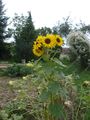
A beautiful sun flower, the only one blooming amid five dozen.


