Difference between revisions of "2008-09-20 52 -0"
imported>Joehardflec (→Expedition) |
imported>FippeBot m (Location) |
||
| (10 intermediate revisions by 6 users not shown) | |||
| Line 2: | Line 2: | ||
| map=<map lat="52" lon="-0" date="2008-09-20" /> | | map=<map lat="52" lon="-0" date="2008-09-20" /> | ||
| lat=52 | | lat=52 | ||
| − | | lon=- | + | | lon=-0 |
| date=2008-09-20 | | date=2008-09-20 | ||
| graticule_name=Northampton | | graticule_name=Northampton | ||
| Line 9: | Line 9: | ||
== About == | == About == | ||
| − | The | + | The actual hash location is at the side of the A47 near East Norton, Leics. |
== Expedition == | == Expedition == | ||
| − | [[User:joehardflec|Joe | + | ===Friday Pre-emptive Balloon Geohash=== |
| − | + | [[User:joehardflec|Joe]] found himself making a pre-emptive visit to the geohash location on the Friday evening (2008-09-19), without knowing the location. | |
| − | I crew for a hot air balloon, launching from King's Norton, Leics, and acting as volunteer ground crew. | + | |
| − | On this occasion, we set up the balloon at around 5pm on | + | He writes... I crew for a hot air balloon, launching from King's Norton, Leics, and acting as volunteer ground crew. On this occasion, we set up the balloon at around 5pm on Friday 19th, and after take off, followed its course on retrieve. The balloon landed in a field at approx 52.594600, -0.833000 (co-ordinates taken from Google maps satellite images). After packing the equipment away, the balloon passengers were taken to their vehicles (which had been brought to a nearby layby by family members) to return home, and my mum and I waited at the bus stop at 52.594350, -0.832000 for our vehicle to return around 5 minutes later to pick us up. |
When I got home, I logged onto the internet, and was astonished to see that the geohash generated for the Saturday, which I had not yet checked, was on the road we had passed through, VERY near to the field the balloon landed in, and the balloon must have passed almost straight over it. | When I got home, I logged onto the internet, and was astonished to see that the geohash generated for the Saturday, which I had not yet checked, was on the road we had passed through, VERY near to the field the balloon landed in, and the balloon must have passed almost straight over it. | ||
| + | ==Saturday 'Meetup'== | ||
| + | On the Saturday, we were once again crewing, this time the launch field was near Oakham, so we travelled back along the A47, achieving a drive through geohash on the outward and return journeys. We passed through the location at around 4:20 pm on the outward journey, 20 mins after the official meetup time (unfortunately, no-one else was in sight, otherwise we would have stopped). We returned through the point at around 9pm. | ||
| + | |||
===Verification=== | ===Verification=== | ||
| − | Unfortunately, we | + | Unfortunately, we did not at the time have a GPS device, but we do have some photos taken during the two flights, and the outward journey. |
| − | |||
| − | |||
| − | |||
| + | ==Gallery== | ||
<gallery perrow="3"> | <gallery perrow="3"> | ||
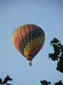
Image:2008-09-20 52 -0 Alpha.jpg | Balloon in flight, taken from 52.596200,-0.851500 | Image:2008-09-20 52 -0 Alpha.jpg | Balloon in flight, taken from 52.596200,-0.851500 | ||
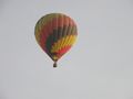
Image:2008-09-20 52 -0 Beta.jpg | in flight, taken from tugby layby (52.598401,-0.867668) | Image:2008-09-20 52 -0 Beta.jpg | in flight, taken from tugby layby (52.598401,-0.867668) | ||
Image:2008-09-20 52 -0 Gamma.jpg | exiting tugby layby (I think) | Image:2008-09-20 52 -0 Gamma.jpg | exiting tugby layby (I think) | ||
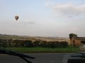
| + | Image:2008-09-20 52 -0 Delta.jpg | Balloon in flight near Oakham, on the day. | ||
| + | Image:2008-09-20 52 -0 Epsilon.jpg | Passing through the location, 2008-09-20 16:20 | ||
</gallery> | </gallery> | ||
| − | |||
| − | |||
[[Category:Expeditions]] | [[Category:Expeditions]] | ||
[[Category:Expeditions with photos]] | [[Category:Expeditions with photos]] | ||
[[Category:Expedition without GPS]] | [[Category:Expedition without GPS]] | ||
| − | |||
[[Category:Coordinates reached]] | [[Category:Coordinates reached]] | ||
| − | + | {{location|GB|ENG|LEC}} | |
| − | |||
| − | |||
| − | |||
| − | |||
| − | |||
| − | |||
| − | |||
Latest revision as of 00:00, 8 August 2019
| Sat 20 Sep 2008 in Northampton: 52.5939233, -0.8365649 geohashing.info google osm bing/os kml crox |
Contents
About
The actual hash location is at the side of the A47 near East Norton, Leics.
Expedition
Friday Pre-emptive Balloon Geohash
Joe found himself making a pre-emptive visit to the geohash location on the Friday evening (2008-09-19), without knowing the location.
He writes... I crew for a hot air balloon, launching from King's Norton, Leics, and acting as volunteer ground crew. On this occasion, we set up the balloon at around 5pm on Friday 19th, and after take off, followed its course on retrieve. The balloon landed in a field at approx 52.594600, -0.833000 (co-ordinates taken from Google maps satellite images). After packing the equipment away, the balloon passengers were taken to their vehicles (which had been brought to a nearby layby by family members) to return home, and my mum and I waited at the bus stop at 52.594350, -0.832000 for our vehicle to return around 5 minutes later to pick us up.
When I got home, I logged onto the internet, and was astonished to see that the geohash generated for the Saturday, which I had not yet checked, was on the road we had passed through, VERY near to the field the balloon landed in, and the balloon must have passed almost straight over it.
Saturday 'Meetup'
On the Saturday, we were once again crewing, this time the launch field was near Oakham, so we travelled back along the A47, achieving a drive through geohash on the outward and return journeys. We passed through the location at around 4:20 pm on the outward journey, 20 mins after the official meetup time (unfortunately, no-one else was in sight, otherwise we would have stopped). We returned through the point at around 9pm.
Verification
Unfortunately, we did not at the time have a GPS device, but we do have some photos taken during the two flights, and the outward journey.
Gallery

Balloon in flight, taken from 52.596200,-0.851500
in flight, taken from tugby layby (52.598401,-0.867668)
exiting tugby layby (I think)
Balloon in flight near Oakham, on the day.
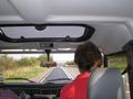
Passing through the location, 2008-09-20 16:20


