Difference between revisions of "2008-09-23 49 10"
(comment1, http://pavelromaniko.com/ where to buy levitra, http://thehuckabees.com/ interaction retin a and seborrhea, http://pengumaniac4.com/ levitra, http://disekt.com/ ambien mouth, http://grapewar) |
imported>NWoodruff |
||
| Line 1: | Line 1: | ||
| − | + | {{meetup graticule | |
| + | | map=<map lat="49" lon="10" date="2008-09-23" /> | ||
| + | | lat=49 | ||
| + | | lon=10 | ||
| + | | date=2008-09-23 | ||
| + | | graticule_name=Bamberg | ||
| + | | graticule_link=Bamberg, Germany | ||
| + | }}== Location == | ||
| + | |||
| + | Today's location is at the edge between a freshly plowed field and some kind of orchard near Bibergau (also called Biebergau) and Dettelbach-Bahnhof, both boroughs of Dettelbach. The next bigger cities are Kitzingen and Würzburg. | ||
| + | There was a small difference between the area expected from the official implementation's satellite view and what was found on site: The [http://www.geodaten.bayern.de/BayernViewer/index.cgi?rw=4363450&hw=5518900&layer=TK&step=4 Bavarian Land Surveying Office's aerial image data] (which Danatar checked because it has better resolution) is more recent than Google's data, but not as recent as reality; irc.peeron.com showed '''one''' building, bayernviewer.de showed '''two''' buildings, but [http://en.wikipedia.org/wiki/The_Matrix reality] had '''three''' of them (see image 1). | ||
| + | |||
| + | == Expedition ([[User:Danatar|Danatar]])== | ||
| + | |||
| + | Only 0.25% of this graticule are nearer to Danatar's door in the neighboring [[Würzburg, Germany|Würzburg (49, 9)]] graticule, so he took his bike and set out for a quick tour before lunch. There was nothing special on his way to the hashpoint, it was not very warm (between 7 and 9°C according to the internet, [[Cold Geohash|unfortunately no thermometer]] at the hashpoint) and some raindrops fell. Once there, he found out that the farm next to the hashpoint had changed even more than had been visible from the satellite photos (see above), but access to the hashpoint was not restricted and so some pictures were taken. On his way back, the rain got a little more intense (which helped with cycling) and Danatar found a shortcut (shorter AND less hills), so he even reached the student cafeteria in time for lunch when he had been sure that he would be too late. Distance cycled: 14.4km + 14.1km = 28.5km. | ||
| + | |||
| + | Nobody seems to have visited this graticule before. You can see Danatar's bike in photo 3. And he still doesn't own a GPS. | ||
| + | |||
| + | |||
| + | {{Virgin graticule | latitude = 49 | longitude = 10 | date = 2008-09-23 | name = Danatar }} | ||
| + | {{No_batteries_geohash | latitude = 49 | longitude = 10 | date = 2008-09-23 | name = Danatar }} | ||
| + | |||
| + | |||
| + | <gallery> | ||
| + | Image:2008-09-23_49_10-1satvergleich.jpg|Different satellite views: Google vs. Bavarian land surveying office | ||
| + | Image:2008-09-23_49_10-2dettelbachbhf.jpg|Dettelbach-Bahnhof ("Dettelbach train station") town sign | ||
| + | Image:2008-09-23_49_10-3orchard.jpg|Not very old orchard with hashpoint at the other end. | ||
| + | Image:2008-09-23_49_10-4athash.jpg|Coordinates reached | ||
| + | Image:2008-09-23_49_10-5hp_overview.jpg|Overview of hashpoint area. You can see the orchard's grass and the plowed field next to it. | ||
| + | </gallery> | ||
| + | |||
| + | ===Revisit on [[2009-05-30 49 10|2009-05-30]]=== | ||
| + | On my way back from the hashpoint, I had to pass within 300 m of this hashpoint. I made a tiny detour to take this picture: | ||
| + | <gallery> | ||
| + | Image:2009-05-30_49_10_revisit20080923.jpg|8 months later | ||
| + | </gallery> | ||
| + | |||
| + | [[Category:Expeditions]] | ||
| + | [[Category:Expeditions with photos]] | ||
| + | [[Category:Expedition without GPS]] | ||
| + | [[Category:Coordinates reached]] | ||
| + | [[Category:Danatar]] | ||
Revision as of 16:11, 15 February 2010
| Tue 23 Sep 2008 in Bamberg: 49.7903942, 10.1073129 geohashing.info google osm bing/os kml crox |
Location
Today's location is at the edge between a freshly plowed field and some kind of orchard near Bibergau (also called Biebergau) and Dettelbach-Bahnhof, both boroughs of Dettelbach. The next bigger cities are Kitzingen and Würzburg. There was a small difference between the area expected from the official implementation's satellite view and what was found on site: The Bavarian Land Surveying Office's aerial image data (which Danatar checked because it has better resolution) is more recent than Google's data, but not as recent as reality; irc.peeron.com showed one building, bayernviewer.de showed two buildings, but reality had three of them (see image 1).
Expedition (Danatar)
Only 0.25% of this graticule are nearer to Danatar's door in the neighboring Würzburg (49, 9) graticule, so he took his bike and set out for a quick tour before lunch. There was nothing special on his way to the hashpoint, it was not very warm (between 7 and 9°C according to the internet, unfortunately no thermometer at the hashpoint) and some raindrops fell. Once there, he found out that the farm next to the hashpoint had changed even more than had been visible from the satellite photos (see above), but access to the hashpoint was not restricted and so some pictures were taken. On his way back, the rain got a little more intense (which helped with cycling) and Danatar found a shortcut (shorter AND less hills), so he even reached the student cafeteria in time for lunch when he had been sure that he would be too late. Distance cycled: 14.4km + 14.1km = 28.5km.
Nobody seems to have visited this graticule before. You can see Danatar's bike in photo 3. And he still doesn't own a GPS.
Danatar earned the No Batteries Geohash Achievement
|
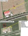
Different satellite views: Google vs. Bavarian land surveying office
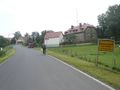
Dettelbach-Bahnhof ("Dettelbach train station") town sign
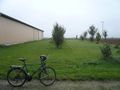
Not very old orchard with hashpoint at the other end.
Coordinates reached
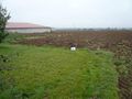
Overview of hashpoint area. You can see the orchard's grass and the plowed field next to it.


Revisit on 2009-05-30
On my way back from the hashpoint, I had to pass within 300 m of this hashpoint. I made a tiny detour to take this picture:
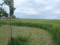
8 months later
