Difference between revisions of "2008-10-17 53 -2"
From Geohashing
imported>Styles m (→About) |
imported>FippeBot m (Location) |
||
| (3 intermediate revisions by 3 users not shown) | |||
| Line 8: | Line 8: | ||
== About == | == About == | ||
| − | |||
This one's near a little country lane -sort of- on the way to chester. But looks to be on the edge of a field (as usual it seems). | This one's near a little country lane -sort of- on the way to chester. But looks to be on the edge of a field (as usual it seems). | ||
Not particularly far off the A51. | Not particularly far off the A51. | ||
| Line 14: | Line 13: | ||
== Planned Expeditions == | == Planned Expeditions == | ||
| − | === Styles === | + | === [[User:Styles|Styles]] === |
| − | It's going to be a night run. Should be interesting if I can find my first geohash in the dark. | + | It's going to be a night run. Should be interesting if I can find my first ever geohash, and in the dark too. |
* Pick up a couple of friends around 8 from Northwich. | * Pick up a couple of friends around 8 from Northwich. | ||
* Drive as close as possible (thank you google maps!) without getting lost within the country lanes. | * Drive as close as possible (thank you google maps!) without getting lost within the country lanes. | ||
* Look for opportunities to get to the geohash location and if we find it, take photos etc. | * Look for opportunities to get to the geohash location and if we find it, take photos etc. | ||
| + | == Expeditions == | ||
| + | === [[User:Styles|Styles]] === | ||
| + | Left a little bit later than I intended. Some how managed to talk my friends into doing this geohashing. | ||
| + | *Took a wrong turn down a country lane. Google maps strike again. | ||
| + | *Managed to locate a route into the field with the geohash location. | ||
| + | *The field was damp underfoot and almost ruined my trainers. | ||
| + | *Eventually found the spot using my phone's gps maping. | ||
| + | |||
| + | <gallery perrow="3"> | ||
| + | Image:2008_10_17_53_-2_google.JPG|I trust my GPS on my phone that well, this image helped when using my phone GPS. | ||
| + | Image:2008_10_17_53_-2_IMG_9265.jpg|My with a few friends by the tree, where the geohash location was. | ||
| + | Image:2008_10_17_53_-2_IMG_9267.jpg|The indecicive GPS on my phone, but we made it. | ||
| + | </gallery> | ||
| + | |||
| + | |||
| + | {{drag-along | ||
| + | |||
| + | | latitude = 53 | ||
| + | | longitude = -2 | ||
| + | | date = 2008-10-17 | ||
| + | | name = Styles | ||
| + | | image = 2008_10_17_53_-2_IMG_9265.jpg | ||
| + | |||
| + | }} | ||
| − | [[Category: | + | [[Category:Expeditions]] |
| + | [[Category:Expeditions with photos]] | ||
| + | [[Category:Coordinates reached]] | ||
| + | [[Category:Meetup on 2008-10-17]] | ||
| + | [[Category:Meetup in 53 -2]] | ||
| + | {{location|GB|ENG|CHW}} | ||
Latest revision as of 00:23, 8 August 2019
| Fri 17 Oct 2008 in Manchester: 53.1594105, -2.7776510 geohashing.info google osm bing/os kml crox |
About
This one's near a little country lane -sort of- on the way to chester. But looks to be on the edge of a field (as usual it seems). Not particularly far off the A51.
Planned Expeditions
Styles
It's going to be a night run. Should be interesting if I can find my first ever geohash, and in the dark too.
- Pick up a couple of friends around 8 from Northwich.
- Drive as close as possible (thank you google maps!) without getting lost within the country lanes.
- Look for opportunities to get to the geohash location and if we find it, take photos etc.
Expeditions
Styles
Left a little bit later than I intended. Some how managed to talk my friends into doing this geohashing.
- Took a wrong turn down a country lane. Google maps strike again.
- Managed to locate a route into the field with the geohash location.
- The field was damp underfoot and almost ruined my trainers.
- Eventually found the spot using my phone's gps maping.
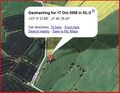
I trust my GPS on my phone that well, this image helped when using my phone GPS.
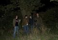
My with a few friends by the tree, where the geohash location was.
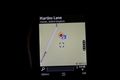
The indecicive GPS on my phone, but we made it.


Styles earned the Drag-along achievement
|