2008-10-26 49 8
From Geohashing
Revision as of 15:04, 24 October 2008 by imported>Ilpadre (New page: {{meetup graticule | map=<map lat="49" lon="8" date="2008-10-26" /> | lat=49 | lon=8 | date=2008-10-26 | graticule_name=Mannheim | graticule_link=Mannheim, Germany }}__NOTOC__ == Location ...)
| Sun 26 Oct 2008 in Mannheim: 49.3791181, 8.7210166 geohashing.info google osm bing/os kml crox |
Location
Today's hashpoint is located in the Odenwald, near Heidelberg, at an altitude of 462 m.
Expedition
ilpadre
Planning: Again, the hashpoint is reachable by foot, though it will be more difficult this time. A footpath through the woods is about 40 m away from the hashpoint. I don't own a GPS device, but I'm confident that I’ll find the spot.
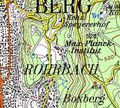
Topographic map with hashpoint marker
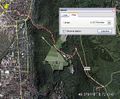
Planned route

