Difference between revisions of "2008-11-11 53 10"
From Geohashing
imported>Peter (New page: {{meetup graticule | map=<map lat="53" lon="10" date="2008-11-11" width="310" height="440" /> | lat=53 | lon=10 | date=2008-11-11 | graticule_name=Hamburg, Germany | graticule_link=Hamburg...) |
imported>NWoodruff |
||
| Line 27: | Line 27: | ||
[[Category:Expeditions]] | [[Category:Expeditions]] | ||
[[Category:Expeditions with photos]] | [[Category:Expeditions with photos]] | ||
| + | [[Category:Coordinates reached]] | ||
Revision as of 20:44, 23 August 2012
| Tue 11 Nov 2008 in Hamburg, Germany: 53.6468071, 10.1389912 geohashing.info google osm bing/os kml crox |
Contents
Location
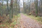
Easy to reach, the point was in the north-east of the town, nearly exactly on the path shown in the picture.
Expedition
Peter
Got there by hvv and walking. Not having planned any particular route I ended up only following my GPS and trespassing a small forest which was not really necessary (I discovered that on my way back). Only met a few random people who seemed to be rather confused about me taking photos there. Anyway, it was raining all the time so I didn't stay very long. Was fun nonetheless somehow. Yay first hash!
Pictures
- not all that spectacular
taken from the point
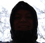
taken against the sky so the camera wouldnt get wet, i guess it's not exactly waterproof...
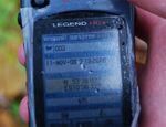
Position


