Difference between revisions of "2008-11-13 54 10"
imported>Sirith m |
(per Renaming Proposal) |
||
| (12 intermediate revisions by 3 users not shown) | |||
| Line 6: | Line 6: | ||
| graticule_name=Kiel | | graticule_name=Kiel | ||
| graticule_link=Kiel, Germany }} | | graticule_link=Kiel, Germany }} | ||
| + | |||
| + | ==Participants== | ||
| + | [[User:Sirith|Sirith]] was on this Expedition. | ||
| + | |||
==Expedition== | ==Expedition== | ||
| − | While sitting in University, we were browsing the geohashing | + | While sitting in University, we (Florian and me) were browsing the geohashing site as part of our regular Morning Coffee. I recognized the location and phoned my father to borrow his GPS device. We were on our way! |
| − | Taking the | + | Taking the bus through Kiel and getting the device was the easier part, sitting in the bus for about 40 minutes was not. Good luck we had 2 notebooks to charge the GPS over USB to prevent powerloss ;). (We were also pretty charged, as we bought some cheap energy drink but Florian spilled most of his on the floor.) |
| + | Arriving at Lehmkaten, which measures about 200m in both direction, we faced a nice green field which was nicely moisturized by heavy rain the other day. Both in wearing sneakers, we tended to look for the shortest way over the acre. We survived a small trench without any serious injuries :p. Digging through the mud, we found our target destination with minor effort, but it was totally worth it! | ||
| − | <gallery perrow=" | + | ==Gallery== |
| + | <gallery perrow="3"> | ||
Image:Xkcd_geohash_2008-11-13_54-10_sat.png|Sat image of the region. | Image:Xkcd_geohash_2008-11-13_54-10_sat.png|Sat image of the region. | ||
| + | Image:Xkcd_geohash_2008-11-13_54-10_route.png|Our route, picking up a GPS. | ||
| + | Image:200811131315_206.jpg|Proof? | ||
| + | Image:200811131314_203.jpg|PROOF! | ||
</gallery> | </gallery> | ||
| + | |||
| + | I made a Photosynth[http://photosynth.net/view.aspx?cid=c201e7a7-c143-4260-82c4-482f02209dd0&i=0:1:11&z=324.4933400000001&g=1&p=0:0&m=false&c=0.867812:0.60256:-0.139335&d=-1.14525:1.15387:1.25256] of the surroundings. | ||
| + | |||
| + | [[User:Sirith|Sirith]] 14:37, 13 November 2008 (UTC) | ||
| + | |||
| + | [[Category:Graticule unlocked achievement]] | ||
| + | [[Category:Expeditions]] | ||
| + | [[Category:Expeditions with photos]] | ||
| + | [[Category:Coordinates reached]] | ||
| + | {{location|DE|SH|RD}} | ||
Latest revision as of 02:58, 20 March 2024
| Thu 13 Nov 2008 in Kiel: 54.4177628, 10.1242402 geohashing.info google osm bing/os kml crox |
Participants
Sirith was on this Expedition.
Expedition
While sitting in University, we (Florian and me) were browsing the geohashing site as part of our regular Morning Coffee. I recognized the location and phoned my father to borrow his GPS device. We were on our way! Taking the bus through Kiel and getting the device was the easier part, sitting in the bus for about 40 minutes was not. Good luck we had 2 notebooks to charge the GPS over USB to prevent powerloss ;). (We were also pretty charged, as we bought some cheap energy drink but Florian spilled most of his on the floor.) Arriving at Lehmkaten, which measures about 200m in both direction, we faced a nice green field which was nicely moisturized by heavy rain the other day. Both in wearing sneakers, we tended to look for the shortest way over the acre. We survived a small trench without any serious injuries :p. Digging through the mud, we found our target destination with minor effort, but it was totally worth it!
Gallery
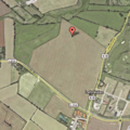
Sat image of the region.
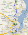
Our route, picking up a GPS.
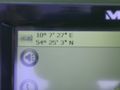
Proof?
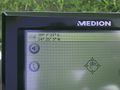
PROOF!


I made a Photosynth[1] of the surroundings.
Sirith 14:37, 13 November 2008 (UTC)