Difference between revisions of "2008-11-15 46 -89"
imported>Twisteguy22 |
imported>FippeBot m (Location) |
||
| (19 intermediate revisions by 3 users not shown) | |||
| Line 1: | Line 1: | ||
| − | |||
{{meetup graticule | {{meetup graticule | ||
| − | | map=<map lat= | + | | map=<map lat=46 lon=-89 date=2008-11-15/> |
| lat=46 | | lat=46 | ||
| lon=-89 | | lon=-89 | ||
| Line 8: | Line 7: | ||
<!-- edit as necessary --> | <!-- edit as necessary --> | ||
| − | |||
| − | |||
| − | |||
| − | |||
| − | |||
| − | |||
== Expedition == | == Expedition == | ||
| + | We started out at around 2 o'clock. It was around a hour and half trip. We don't know if we were early for the 4 o'clock meetup, because when we got there the geohash was right between the time zones. It was below freezing and a little snowy when we got there. It was also opening day. Orange vests speckled the woodland's arboreal heights. The actual hash was in a field and had some dilapidated out buildings around it. We went inside one and found all sorts of old tools like huge circular saw blades. We also found an old trunk in one building. it contained a large wasp nest. Fortunately, it was cold and the wasps were quite sessile in their brumal hibernations. We then spread out a heavy mil garbage bag and sat around and ate raisins and walnuts, chips, and an apple. It was dark when we got back. | ||
| − | + | == Participants == | |
| − | == | + | Hurricane, Susan, Avery |
| − | |||
== Photos == | == Photos == | ||
<gallery perrow="3"> | <gallery perrow="3"> | ||
| − | Image: | + | Image:2_2008-11-15 46 -89.JPG | Hurricane, His grandma Susie, and his friend Avery's hood. |
| − | Image: | + | Image:1_2008-11-15_46_-89.jpg | proof |
</gallery> | </gallery> | ||
| − | |||
| − | |||
| − | |||
[[Category:Expeditions]] | [[Category:Expeditions]] | ||
[[Category:Expeditions with photos]] | [[Category:Expeditions with photos]] | ||
| − | |||
| − | |||
[[Category:Coordinates reached]] | [[Category:Coordinates reached]] | ||
| − | + | {{location|US|MI|ON}} | |
| − | |||
| − | |||
| − | |||
| − | |||
| − | |||
| − | |||
Latest revision as of 01:56, 6 August 2019
| Sat 15 Nov 2008 in 46,-89: 46.5220956, -89.1288515 geohashing.info google osm bing/os kml crox |
Expedition
We started out at around 2 o'clock. It was around a hour and half trip. We don't know if we were early for the 4 o'clock meetup, because when we got there the geohash was right between the time zones. It was below freezing and a little snowy when we got there. It was also opening day. Orange vests speckled the woodland's arboreal heights. The actual hash was in a field and had some dilapidated out buildings around it. We went inside one and found all sorts of old tools like huge circular saw blades. We also found an old trunk in one building. it contained a large wasp nest. Fortunately, it was cold and the wasps were quite sessile in their brumal hibernations. We then spread out a heavy mil garbage bag and sat around and ate raisins and walnuts, chips, and an apple. It was dark when we got back.
Participants
Hurricane, Susan, Avery
Photos
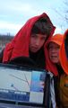
Hurricane, His grandma Susie, and his friend Avery's hood.
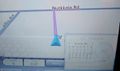
proof

